Monday, October 28, 2019

Pico de Orizaba

Honestly, getting to a summit elevation not about 18500 feet above sea level was easier than I expected. I guess I had stigmatized high altitude in my mind as something very extreme; that pretty much everyone gets some form of AMS when you get that high, but that wasn't the case. After about a day and a half, our run to the summit felt no different and in some cases, easier, than a walk to the top of the Grand Teton, a backcountry skin to the summit of Mt Nebo, or a long run in the Unitas that crests over 12000 feet that I have become accustomed to. Don't get me wrong, it was an amazing experience, summiting Citlaltepetl (pico de orizaba), Mexico's highest peak and the third tallest in North America, but it wasn't what I expected; maybe i was lucky with the altitude. 
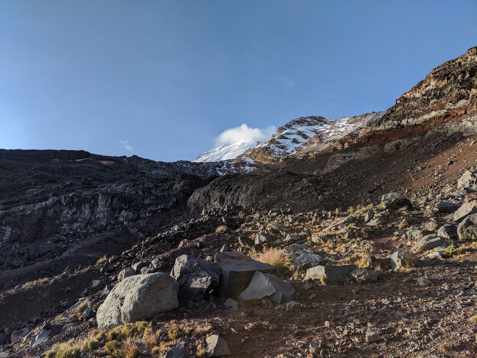
Pico De Orizaba from 16,600 ft just below the Glacier on Acclimatization Day

After arriving in Mexico City, bumbling through a discussion in Spanish with our transportation (my Spanish is terrible), and a 3.5 hour drive, Clayton and I arrived in a rainy Tlachichuca at the Museum/climbing hostel/residence of Dr Reyes and the Reyes family and headquarters of Servimont, whom we used for transportation and logistics. Thursday stay at the Servimont headquarters was excellent, we had the entire place to ourselves and dinner and breakfast were both 3 course meals cooked to order exclusively for us two. After procuring some last minute supplies and packing up just the gear we needed on the mountain, we set off in a decked out Dodge truck. For those reading for the trip report, the drive up to the Refugio Piedre Grande hut up on the mountain is pretty rough and i would recommend hiring one of the local guides, at the very minimum for transportation up to the hut, and you need about 40 pesos (as of 2019) each to get into the National Park.
Clouds hang around the canyons below the Piedre Grande hut on Pico De Orizaba

Thursday afternoon we stepped into the hut for the first time, greeted by a crew from Wyoming who had just finished a fifth of tequila waiting out the rain 
"Hey, do you guys have any Tequila?? No... Cervesa?? No... Weed? No... Ok, we can still be friends"
I chose to go for a walk Thursday to get used to the thinner 14000 foot air that we would be living in for the next two days. Walking around the mid mountain area was pretty amazing, even though i didn't have the jaw dropping views we would have later in the week. The plant life in Mexico at 14000 feet and above the Mexican rain forest is vaguely familiar, but quite foreign at the same time. On the right: Home for the duration of our stay on the mountain, inside the Piedre Grande Hut


Friday morning we woke up early, at 12:30 am to be specific, as some other groups (a Mexican crew, some guys from Toronto, and they Wyomingites) got geared up for an ascent of the mountain. At 6 am Clayton and I woke up and started up just before sunrise for an acclimatization hike and to find the route through the infamous Labyrinth, supposedly a route-finding nightmare. As the sun rose over the now clear sky, we were greeted by the amazing expansive views of the Mexican high rain forest below, and the summit with freshly fallen snow up high. On our first ascent through the labyrinth, we followed the Wyoming crew's tracks up what we would discover was the incorrect route. Once we got up to our high point, ~16600 feet just below the glacier, it was clear where the actual path was. At about 11 am we turned back, ready for a hearty lunch and rest, prepping for our full ascent the following morning. I should note, i heard a lot about how difficult route finding through the labyrinth was. After finding the correct way and noting two key turns we needed to make, I thought the route was actually pretty straight forward (however the Canadians remarked that they would never have made it through without a guide). Maybe it is years of route finding training in Arizona, but the route is actually pretty easy to follow. The true route through does not follow the trail noted on most topographic maps (for the reason that will be noted later). We spent the rest of Friday resting and eating and went to bed at 6pm in anticipation of our 12:30 am wake up on Saturday for our summit push. Above left: Sunrise on the flanks of Pico de Orizaba. Below left: an aqueduct that serves as a sidewalk approach to the mountain from the Piedre Grande Hut.


View of the Labyrinth and Summit on our Acclimatization Day


The planned 12:30 am wake up call quickly became an 11:45 PM wake up instead. Unfortunately due to the close quarters in the hut, when one person gets up, everyone gets up. By 12:20 we were suited up and set off. One perk of going in a small, unguided group, is that we don't take a ton of time to get ready. We were the first group out by about a half hour. 
Chatting with one of the guided groups, they remarked "oh, you two were the two headlamps we saw way up near the top??"
One of the biggest unsung praises of alpine climbing to me is the peace. Walking in the calm still of the night, under the moon and stars for 7 hours with the many small towns of rural mexico sprawling below you, that's an experience that words and pictures can't replicate. The night sky has an unbelievable clarity at such high altitudes and the stars and moon were visible with a clarity that i had never before experienced. 

Above Left: Moonshine, Stars and whispy clouds at 4 am over the upper reaches of Pico de Orizaba.
Above right: Sunrise over the Glacier Gran Norte at 17,500 feet

Our run through the Labyrinth the day before was fruitful as we waltzed right through without any backtracking and by 5 am we were strapping on crampons, roped up and moving over snow and ice to the summit! Shortly after sunrise we were on top taking in the views and enjoying success. 

Sunrise Walking up the Glacier

The Final bit of climbing on the right once we reached the crater of Pico de Orizaba

Looking down into the Orizaba Crater. Apparently there has been a high line set up over the crater at some point (we found high lining gear on the summit)

Looking out towards the Sea. The lower mountains visible are 10,000+ feet lower than we are at the moment.
Clayton and I on the Summit


On the way down we took a peak into the crevasses, there are only a few on the upper mountain and they are pretty easily identified and avoided. The sun came out and things got hot fast, by the time we got back off the glacier (after longingly watching our Wyoming brethren ski from the summit) i stripped down to only my Houdini shell. The daytime heat sublimated some snow, which super-saturated the air making for some interesting greenhouseing and fog at mid elevations on the peak. A few hours later we were back at the hut and cooking some mac and cheese to satiate our summit push hunger! After a brief pack and loading our gear into the 1962 dodge power wagon (amazing that Servimont is still using this as a daily driver up this rugged road, a testament to how well built it was!) we were back at the Servimont headquarters reveling in our success of a quick 48 hour acclimatization and ascent of the 3rd tallest peak in North America. Our route map is below. Really the key is to stay right immediately after the initial steep hill gaining 1000 feet, then go left directly into the labyrinth when the trail takes you up into it. If you can get this key left down, the rest of the route is pretty straight forward and simple to follow but glacier travel might be a bit more difficult if there has not been snow up there recently. If you are here just for the route description, this is where it ends. 


Just before we leave, we finally get our first view of the mountain from Servimont HQ.

Our Route against the one on the topo on the left, and with a satellite ocerlay on the right. The route deviates from what is marked on the Topo because the glacier and snowfields do not reach as far down the mountain as they once did. Instead of climbing straight up the snow as mountaineers used to, we now have to navigate diagonally through the Labyrinth to get to the glacier. The key to navigation is to stay to the west of the labyrinth longer than you think is necessary (until the kink shown above) then go up a small hole and strike out diagonally through the labyrinth.


The main reason for my post this time was to express my amazement at the slow death of the main route on this amazing peak, and the two other peaks in Mexico that supposedly retain glaciers. Fair warning, i am stepping up on my soap box here for a bit.

While talking with Senior Reyes, who is perhaps one of the best sources of information on the subject, as his family has been up on the mountain for 5 generations or more and helped open the north side glacier route, the topic of climate change and changes on the mountain came up. As in most of the rest of the world, the glaciers of Mexico have been dramatically affected in the past 20 years. By some accounts, the three glaciers on Popocatepetl are gone all together (although in this case the disappearance has been sped by volcanic activity). In the case of the other two peaks, Ixta (which we did not visit) and Pico de Orizaba, the glaciers do not seem to have aged well. Senior Reyes sadly remarked that the glacier has been shrinking dramatically. This was readily apparent when i looked around at the various pictures and route maps that were hanging up throughout the gear room and climber lounge areas.  

In the case of Pico, all but the Gran Galcier Norte ice cap appear to be gone or mostly gone:

A recent Satellite Image of Pico de Orizaba
Glacier Mapping of Pico de Orizaba. Green: Rough map of glacial extent in 1958 over the image of glacial extent in 1998. Compare this to the above current state of the mountain. Image taken from: https://www.sciencedirect.com/science/article/pii/S0016716915000094#fig0030


Even 20 or so years ago, a ski descent of Pico de Orizaba would have been much more appetizing than it is now, adding almost 1000 vertical feet on to the descent you can do today. I wonder how the peak will withstand the next 20 years, and hope that the Reyes family can continue their business even as the peak continues to change dramatically. 


Route pictures from Servimont with a rough position of the present day glacier levels drawn in.

I don't think an actual accounting of the glaciers in Mexico has been done in some time (where markers are placed and used to look for glacial movement, aka to determine if it is indeed still a glacier) but based on satellite pictures of Ixta against glacial mapping from 50 years ago, it looks like Ixta has lost its glaciers as well. The Gran Norte Glacier might be the only true glacier remaining in mexico.

This is the case all across North America really. I read recently that many of the glaciers in Grand Teton National park are being studied with glacial markers to see if there is still any glacial movement, of if these once rivers of ice have devolved into mere ice and permanent snow fields. I would assume the same is likely true for many of the glaciers in Colorado and California as well.

It will be a sad day when the glaciers of Mexico are gone, and with it the unique alpine climbing community that exists down there that revolve around the high elevations of Pico de Orizaba. The main difference of glacial loss here in Mexico versus in Alaska, the Pacific Northwest, Canada, Greenland, the Alps, and other places we traditionally associate with big mountains and endless expanses of ice is that all of these are arctic or near arctic places, known for their cold and snow; going to Mexico, a fairly tropical climate that everyone associates with beaches to climb a big ice covered peak and possibly ski off its summit is a unique experience. I hope that i do manage to ski off the peak before it turns into some small snowfields interspersed between mounds of volcanic ash and sand, remnants of what once was. 

A great documentary i saw a while back looking at glacial ice loss in the more Arctic regions of North America, Chasing Ice, is a must watch for anyone curious or interested in the subject. 

Also, here are some pictures of the crazy and vibrant plant life at 14-15,000ft down in mexico:
Some crazy variant of thistle that looks like purple eyeballs looking at you


Probably the most vibrant Paintbrush i have ever seen

Weird black cobb flowers (i have no idea what this is called

Something that resembles an air plant when young and grows into this thing.


Tuesday, August 20, 2019

When the Desert Waters Flow pt 2

How fitting that a water based trip would need to be 'fluid'. Original plans ranged from a high peaks trip followed by rafting the upper green (scrapped due to large amounts of snow hanging around in the Wind River Range that would make a trip difficult), A trip down the San Juan (never really got off the ground because of permits), a packraft/canyoneering trip on the Escalante (water flow turned off a week before our planned trip), A similar canyoneering/packraft trip on the Dirty Devil (scrapped due to concerns about water quality for drinking and lack of flows), a trip down the Dolores River (a bit farther of a drive), and finally, our plan f... A full descent of the Muddy!

After a whirlwind of last minute planning activities, a final trip plan email was sent out to friends and family and we set off for Hanksville. The plan was to float Muddy Creek from I-70 through the swell to the Hanksville bridge, its entire navigable length before becoming the Dirty Devil river just south of Hanksville. After dropping a car off at the end of an old paved road that mother nature was slowly reclaiming, we drove away to the put in. This area of southern/central Utah is tough to navigate, there are not many paths through the San Rafael Swell, a ridge of uplifted rock that forms an impassible barrier for 75 Miles, with a single dirt road and the blasted path for I-70 passing through its steeply tilted rock layers. Our Journey would take us through some very lonely country indeed, this area was one of the last areas to be put on a map in the continental 48 with some of the slot canyons having not been navigated until the early 2000's (decades after most of the canyons in the greater central/southern Utah area).
Boats are just about packed!

This particular 'river' trip had its own difficulties. We were not expecting to find any drinkable water en-route (the Muddy is... well, extremely muddy, it is also quite saline, the Dirty Devil, the lower continuation, accounts for a disproportionate amount of salt and silt inflow into lake Powell for its small size), so we were planning on packing some 60 Liters or so of water with us along with the rest of our gear which would lead to heavy and fully loaded boats (we opted to not use any internal cargo storage- storing items inside the rafts, due to the possibility that the extremely silty water might prevent the zippers from fully re-sealing). On top of that, we expected some class 2-3 rapids, a shallow river bottom, and miles and miles of unknown floating. What could go wrong? Other than the river drying up on us that is...
Andrew running through his first rapid on the Muddy shortly after putting in

After tucking a car on the side of I-70 We began the re-packing and boat inflating process. The muddy was not as muddy as we had expected and was flowing fast and cool, a welcome relief from the heat. At the beginning of the packing process i heard an ominous hissing sound. Shit some inflatables are gone already? Turns out we had just punctured a beer and a cider, time to down them before we loose em! Turns out these initially lost beers would foreshadow what was to come. Pretty much every day was punctuated in some way with one of our containers - beverage, water, or air holding (boats, seats, pads) would pop.

Setting out between the I-70 Bridges, the muddy was flowing narrow, fast, and as deep as we could ask for. Before long we were greeted with a steady stream of easy rapids in the narrow channel. At this point we were mostly in flat open desert, the rapids were a welcome diversion to help pass the time. Nearly immediately though, it was apparent that Lindsay was having a boat problem. Turns out one of the reinforcement seams had begun to let go because i had not properly welded it. This resulted in a steady stream of air being let out of her tubes. I tried to temporarily patch it with some tape and we set back off. Pretty much immediately we ran into a class 3 drop that snags Andrew. We float on a bit more but it is clear that we are going to have to end early on day one, Lindsay's boat just isn't holding air and Andrew was a bit shaken up by the rapids. So, with only 1.75 miles under our belt and an estimated 70+ (in reality it would be 80+) miles still to go, we pull over to camp, lick our wounds (figuratively), repair a boat, and decide what we are going to do. After some patchwork, a few afternoon thunderstorms, some beer and a few brats we all decide to push on tomorrow and see how it goes. We can bail at a road if we need to and hike about 20 miles back to the car.
The view from Camp on Day 1
Cooking dinner

Day 2: Morning came and with it all of our boats seemed to be in OK shape. The patchwork done on Lindsay's boat was holding so we packed up camp and set off. Expecting another few miles of class 2-3 rapids, and then some easier floating afterwards. What we ran into offered a bit more excitement and some interesting problem solving. The remaining class 3 rapids came and went without issue and we began to enter into some shallow box canyons that were choked with vegetation. At one point the watercourse was completely impassible due to downed wood requiring a guided shuttle of the boats which was made more difficult by the heavily eroded 6 ft deep banks choked with vegetation. In several other instances, large logs completely crossed the watercourse with no option for exiting the water to set up a shuttle, instead we had to hop out, swim under the logs, then pass the boats either over or under them. After a long morning, we finally reached the road crossing. Lonely country indeed, it didn't look like any one had crossed on this road in some time. After a pause for lunch and a group consensus, we decided to continue down. At this point, if we ran into more problems, our best bet would be to just finish the complete river descent as an alternative exit would require 50+ miles of HOT road walking just to get back to the highway with little chance of seeing anyone. Coincidentally, my seat decided to blow out, one more thing to patch.
Admiring the scenery from my boat

The afternoon seemed to drag on as we floated lazily through a wide, flat, and slow section of the river and relatively uninteresting scenery. By early evening, however, we were beginning to enter the Navajo Sandstone and scenery improved. Camp was set up about a half mile upstream from Enigma Canyon so we could potentially run it in the morning if we chose to. The site was on the edge of a fault canyon that ran transverse to the muddy creek gorge. The Geology of this part of the world always amazes. To finish off day 2, some 20 miles into our expected 80 mile float, we had not seen any sign that people had been there in quite a long time which is entirely possible as access would require either a trip down the river (which i am learning is perhaps not as popular as i thought it might be) or else a long trip down dirt roads and hot and ill defined trails. Also, at some point during the day a 4L water container decided to let go in my boat, there went all of our contingency water.
Camp views on day 2

Day 3: At some point during the night, Andrew's pad decided to let go and was now leaking, yet another thing to patch, but we will deal with that later. With boats packed we set off from our beach site for Enigma, which we reached in no time at all. As always it seems, the mouth of enigma was choked with vegetation and after wading for a few minutes through it, we reached the slot! unfortunately, walking up canyon, we could only go for about 5 minutes before we were stopped by a dry fall. Oh well, more river miles today! The goal was to run from our spot near the beginning of the Muddy Creek Gorge all the way past the typical daily run put in area at Tomisch butte and potentially through the Chute itself! When we were here in June the day use area was jam packed with people. I guess the wonder faded a bit as we were most definitely alone out here. The river seemed to be flowing slower but a bit cleaner than when we were here last which made rock identification a tad easier, but my estimated travel times were off. Hoping to have run through the chute on Day 3, we instead found a beautiful sandy perch right before the Chute to camp. In my opinion it was the best site of the trip! Rather than run through the chute which might take a few hours, we camped early to patch a pad and explored the canyons nearby, and dipped into the whisky and tequila we brought along ;)
Andrew checking out Enigma Canyon Deep in the Muddy Creek WSA

Lindsay taking her boat out for a walk. A few days later we would be doing a lot of this. 


Psyched to be in this amazing part of the world with some amazing people.

Beach camp on Day 3

The muddy just before the Chute, what an amazing place!

We noticed a canyon coming in across the creak from camp and decided to explore at sunset.

Day 4: The Money! Immediately after camp, we ran through the Chute which is truly an amazing run! Unfortunately during this section i got pinned on a rock, Andrew tore the bottom of his boat, and a 10L water bladder decided to let go. We emerged from the Chute excited but rather concerned, we still had some water in the 10L that let go but it was now suspect after having mixed with the river water. Over lunch, we discussed strategy and i patched Andrew's boat as best i could (tyvek tape can be a lifesaver here). We set off from Hidden Splendor Mine with an expected 25 miles remaining; we were hoping to get through the reef and out onto the flats, eating as much as possible into any remaining miles due to our dwindling water (something like ~16L of clean water at this point, likely more than enough but i like to keep the margins in my favor). The float through the San Rafael Reef, in my opinion, was the most stunning section of the trip! I am glad we got the opportunity to descend through this section which it seems was not often traveled. The rock is steeply turned and over the course of about 5 miles, we quickly 'ascended' back out ofall of the rock layers we had spend the past few days descending through. At one point, we did have to portage because the creek disappeared underneath an extremely low rock undercut- it looked more like the creek just disappeared into a wall! Once through the reef, the interesting section of our trip was over and we had an expected 20 miles of flats to run through back to the car. This was hopeful at best. We opted for a later day on the now shallow and braided river channel- it was often tough to find where float-able water was which resulted in a short walk required every few minutes. We were making slow progress, and as the day dragged on the bitching increased from all members of the group- well if you are going to bitch about it, you might as well wine too! Happy hour wine on the river with our few remaining cans of wine greatly raised spirits as we began the search for an adequate site to camp. The wind was picking up and we were in a flat, open desert- we would need some sort of wind break for camp, preferably with no sand up wind, something we learned from last year's river trip when a late evening storm rolled through after we had set up camp and Andrew and i got sand blasted all night. Some number of miles later we finally found a suitable site and pulled over- this site was actually my second favorite of the trip.

Ascending? Descending? reversing back through the various rock layers as we pass through the San Rafael Reef, definitely the most scenic section of our float.

Chasing shade on the Muddy

Andrew taking his boat for a walk

Andrew admiring the sunset from camp on day 4

The Sunset from camp on day 4

Andrew chillin

Stack o'boats

Night falls on the desert

Day 5: Water reserves running low, we set off for what we thought should be 10 to no more than 12 miles left. The creek, however, had really began to turn back on itself and one linear mile might actually be 3 river miles or more. As we went on the water got ever warmer and the quality ever worse- half way through the day it was so bad and began to start to smell enough that i no longer wanted to use it for cooling off- its all we had though. The river continued to get shallower and wider resulting in ever more walking- at some points post holing in fluidized sand. By lunch we had covered 12 miles and were seemingly no closer to our exit point. Spirits continued to degrade to an all time low a few hours later as slowly had to walk more than we could float. Some time around 5 PM the car FINALLY came into view and our river float had ended. The flat section had been 10+ miles longer than expected for a total trip length of about 86 miles!
Turd sandwiches for lunch, apparently this particular dish is called "grunch"

Lindsay walking her boat as the Muddy braids out and starts to disappear
Amazing water quality, i guess that's why they call it "Muddy creek"

After hours of grueling boat dragging and walking, we made it back to the car! I was equally glad to be done with the trip as i was that we had been able to go on it.

After retrieving my car from the side of I-70, we set off for green river, a hopeful "bath" in the green river and some food. The green was flowing at ~18,000 cfs, roughly 6-7x normal flows so we decided not to enter the water and found other ways to wash off. With one day remaining in the trip, we decided a quick run through Leprechaun canyon would be a great way to finish the week-finally get a canyon in after having floated nearly 90 miles with canyon gear without ever using it.

Day 6: Leprechaun is a great, albeit very narrow canyon. What made this trip interesting was the spiders. I have never seen so many and such large daddy long leg spiders. hundreds, thousands of them in the canyon, some lone rangers, others in groups of twenty to hundreds, bobbing and weaving as if they were at a techno rave with one leg in the air. It was kind of a crazy sight! One last destination before we went back to Salt Lake, a quick dip in lake Powell to clean off and cook dinner was much deserved! We drove down to Bullfrog, set up some tarps between the cars, went for a dip in the nice clean water and reveled on the experiences of the past few days. Another trip in the books!
The Milky Way rising over the cottonwoods at the Sandthrax camp

I guess you could say it was narrow

Sandstone Glow

Striations and grains in Leprechaun Canyon

Cooking dinner in the shade at lake Powell
Looking forward to what the next float trip will have in store for us!