Tuesday, August 20, 2019

When the Desert Waters Flow pt 2

How fitting that a water based trip would need to be 'fluid'. Original plans ranged from a high peaks trip followed by rafting the upper green (scrapped due to large amounts of snow hanging around in the Wind River Range that would make a trip difficult), A trip down the San Juan (never really got off the ground because of permits), a packraft/canyoneering trip on the Escalante (water flow turned off a week before our planned trip), A similar canyoneering/packraft trip on the Dirty Devil (scrapped due to concerns about water quality for drinking and lack of flows), a trip down the Dolores River (a bit farther of a drive), and finally, our plan f... A full descent of the Muddy!

After a whirlwind of last minute planning activities, a final trip plan email was sent out to friends and family and we set off for Hanksville. The plan was to float Muddy Creek from I-70 through the swell to the Hanksville bridge, its entire navigable length before becoming the Dirty Devil river just south of Hanksville. After dropping a car off at the end of an old paved road that mother nature was slowly reclaiming, we drove away to the put in. This area of southern/central Utah is tough to navigate, there are not many paths through the San Rafael Swell, a ridge of uplifted rock that forms an impassible barrier for 75 Miles, with a single dirt road and the blasted path for I-70 passing through its steeply tilted rock layers. Our Journey would take us through some very lonely country indeed, this area was one of the last areas to be put on a map in the continental 48 with some of the slot canyons having not been navigated until the early 2000's (decades after most of the canyons in the greater central/southern Utah area).
Boats are just about packed!

This particular 'river' trip had its own difficulties. We were not expecting to find any drinkable water en-route (the Muddy is... well, extremely muddy, it is also quite saline, the Dirty Devil, the lower continuation, accounts for a disproportionate amount of salt and silt inflow into lake Powell for its small size), so we were planning on packing some 60 Liters or so of water with us along with the rest of our gear which would lead to heavy and fully loaded boats (we opted to not use any internal cargo storage- storing items inside the rafts, due to the possibility that the extremely silty water might prevent the zippers from fully re-sealing). On top of that, we expected some class 2-3 rapids, a shallow river bottom, and miles and miles of unknown floating. What could go wrong? Other than the river drying up on us that is...
Andrew running through his first rapid on the Muddy shortly after putting in

After tucking a car on the side of I-70 We began the re-packing and boat inflating process. The muddy was not as muddy as we had expected and was flowing fast and cool, a welcome relief from the heat. At the beginning of the packing process i heard an ominous hissing sound. Shit some inflatables are gone already? Turns out we had just punctured a beer and a cider, time to down them before we loose em! Turns out these initially lost beers would foreshadow what was to come. Pretty much every day was punctuated in some way with one of our containers - beverage, water, or air holding (boats, seats, pads) would pop.

Setting out between the I-70 Bridges, the muddy was flowing narrow, fast, and as deep as we could ask for. Before long we were greeted with a steady stream of easy rapids in the narrow channel. At this point we were mostly in flat open desert, the rapids were a welcome diversion to help pass the time. Nearly immediately though, it was apparent that Lindsay was having a boat problem. Turns out one of the reinforcement seams had begun to let go because i had not properly welded it. This resulted in a steady stream of air being let out of her tubes. I tried to temporarily patch it with some tape and we set back off. Pretty much immediately we ran into a class 3 drop that snags Andrew. We float on a bit more but it is clear that we are going to have to end early on day one, Lindsay's boat just isn't holding air and Andrew was a bit shaken up by the rapids. So, with only 1.75 miles under our belt and an estimated 70+ (in reality it would be 80+) miles still to go, we pull over to camp, lick our wounds (figuratively), repair a boat, and decide what we are going to do. After some patchwork, a few afternoon thunderstorms, some beer and a few brats we all decide to push on tomorrow and see how it goes. We can bail at a road if we need to and hike about 20 miles back to the car.
The view from Camp on Day 1
Cooking dinner

Day 2: Morning came and with it all of our boats seemed to be in OK shape. The patchwork done on Lindsay's boat was holding so we packed up camp and set off. Expecting another few miles of class 2-3 rapids, and then some easier floating afterwards. What we ran into offered a bit more excitement and some interesting problem solving. The remaining class 3 rapids came and went without issue and we began to enter into some shallow box canyons that were choked with vegetation. At one point the watercourse was completely impassible due to downed wood requiring a guided shuttle of the boats which was made more difficult by the heavily eroded 6 ft deep banks choked with vegetation. In several other instances, large logs completely crossed the watercourse with no option for exiting the water to set up a shuttle, instead we had to hop out, swim under the logs, then pass the boats either over or under them. After a long morning, we finally reached the road crossing. Lonely country indeed, it didn't look like any one had crossed on this road in some time. After a pause for lunch and a group consensus, we decided to continue down. At this point, if we ran into more problems, our best bet would be to just finish the complete river descent as an alternative exit would require 50+ miles of HOT road walking just to get back to the highway with little chance of seeing anyone. Coincidentally, my seat decided to blow out, one more thing to patch.
Admiring the scenery from my boat

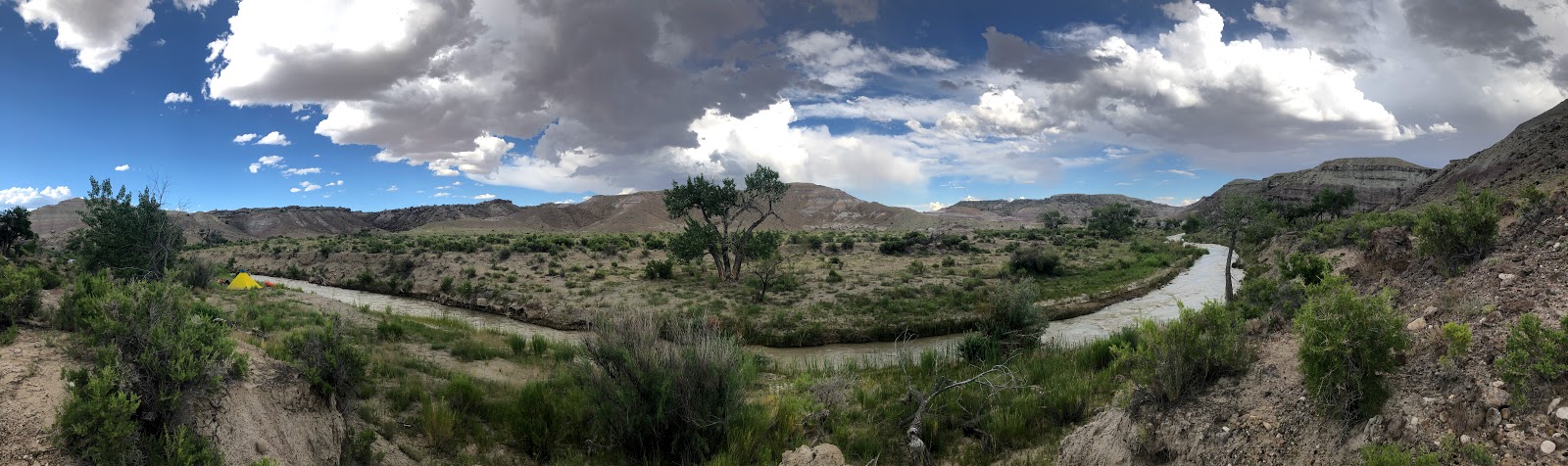
The afternoon seemed to drag on as we floated lazily through a wide, flat, and slow section of the river and relatively uninteresting scenery. By early evening, however, we were beginning to enter the Navajo Sandstone and scenery improved. Camp was set up about a half mile upstream from Enigma Canyon so we could potentially run it in the morning if we chose to. The site was on the edge of a fault canyon that ran transverse to the muddy creek gorge. The Geology of this part of the world always amazes. To finish off day 2, some 20 miles into our expected 80 mile float, we had not seen any sign that people had been there in quite a long time which is entirely possible as access would require either a trip down the river (which i am learning is perhaps not as popular as i thought it might be) or else a long trip down dirt roads and hot and ill defined trails. Also, at some point during the day a 4L water container decided to let go in my boat, there went all of our contingency water.
Camp views on day 2

Day 3: At some point during the night, Andrew's pad decided to let go and was now leaking, yet another thing to patch, but we will deal with that later. With boats packed we set off from our beach site for Enigma, which we reached in no time at all. As always it seems, the mouth of enigma was choked with vegetation and after wading for a few minutes through it, we reached the slot! unfortunately, walking up canyon, we could only go for about 5 minutes before we were stopped by a dry fall. Oh well, more river miles today! The goal was to run from our spot near the beginning of the Muddy Creek Gorge all the way past the typical daily run put in area at Tomisch butte and potentially through the Chute itself! When we were here in June the day use area was jam packed with people. I guess the wonder faded a bit as we were most definitely alone out here. The river seemed to be flowing slower but a bit cleaner than when we were here last which made rock identification a tad easier, but my estimated travel times were off. Hoping to have run through the chute on Day 3, we instead found a beautiful sandy perch right before the Chute to camp. In my opinion it was the best site of the trip! Rather than run through the chute which might take a few hours, we camped early to patch a pad and explored the canyons nearby, and dipped into the whisky and tequila we brought along ;)
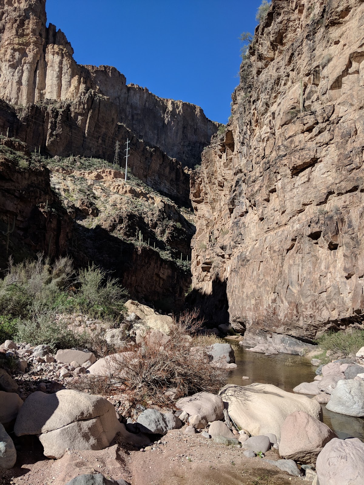
Andrew checking out Enigma Canyon Deep in the Muddy Creek WSA

Lindsay taking her boat out for a walk. A few days later we would be doing a lot of this. 


Psyched to be in this amazing part of the world with some amazing people.
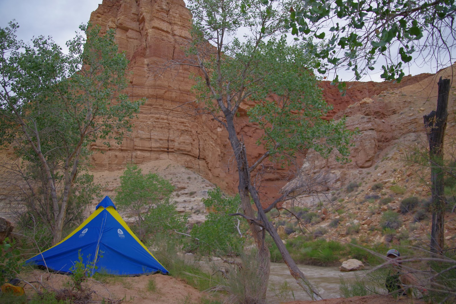
Beach camp on Day 3

The muddy just before the Chute, what an amazing place!

We noticed a canyon coming in across the creak from camp and decided to explore at sunset.

Day 4: The Money! Immediately after camp, we ran through the Chute which is truly an amazing run! Unfortunately during this section i got pinned on a rock, Andrew tore the bottom of his boat, and a 10L water bladder decided to let go. We emerged from the Chute excited but rather concerned, we still had some water in the 10L that let go but it was now suspect after having mixed with the river water. Over lunch, we discussed strategy and i patched Andrew's boat as best i could (tyvek tape can be a lifesaver here). We set off from Hidden Splendor Mine with an expected 25 miles remaining; we were hoping to get through the reef and out onto the flats, eating as much as possible into any remaining miles due to our dwindling water (something like ~16L of clean water at this point, likely more than enough but i like to keep the margins in my favor). The float through the San Rafael Reef, in my opinion, was the most stunning section of the trip! I am glad we got the opportunity to descend through this section which it seems was not often traveled. The rock is steeply turned and over the course of about 5 miles, we quickly 'ascended' back out ofall of the rock layers we had spend the past few days descending through. At one point, we did have to portage because the creek disappeared underneath an extremely low rock undercut- it looked more like the creek just disappeared into a wall! Once through the reef, the interesting section of our trip was over and we had an expected 20 miles of flats to run through back to the car. This was hopeful at best. We opted for a later day on the now shallow and braided river channel- it was often tough to find where float-able water was which resulted in a short walk required every few minutes. We were making slow progress, and as the day dragged on the bitching increased from all members of the group- well if you are going to bitch about it, you might as well wine too! Happy hour wine on the river with our few remaining cans of wine greatly raised spirits as we began the search for an adequate site to camp. The wind was picking up and we were in a flat, open desert- we would need some sort of wind break for camp, preferably with no sand up wind, something we learned from last year's river trip when a late evening storm rolled through after we had set up camp and Andrew and i got sand blasted all night. Some number of miles later we finally found a suitable site and pulled over- this site was actually my second favorite of the trip.

Ascending? Descending? reversing back through the various rock layers as we pass through the San Rafael Reef, definitely the most scenic section of our float.

Chasing shade on the Muddy

Andrew taking his boat for a walk

Andrew admiring the sunset from camp on day 4

The Sunset from camp on day 4

Andrew chillin

Stack o'boats

Night falls on the desert

Day 5: Water reserves running low, we set off for what we thought should be 10 to no more than 12 miles left. The creek, however, had really began to turn back on itself and one linear mile might actually be 3 river miles or more. As we went on the water got ever warmer and the quality ever worse- half way through the day it was so bad and began to start to smell enough that i no longer wanted to use it for cooling off- its all we had though. The river continued to get shallower and wider resulting in ever more walking- at some points post holing in fluidized sand. By lunch we had covered 12 miles and were seemingly no closer to our exit point. Spirits continued to degrade to an all time low a few hours later as slowly had to walk more than we could float. Some time around 5 PM the car FINALLY came into view and our river float had ended. The flat section had been 10+ miles longer than expected for a total trip length of about 86 miles!
Turd sandwiches for lunch, apparently this particular dish is called "grunch"

Lindsay walking her boat as the Muddy braids out and starts to disappear
Amazing water quality, i guess that's why they call it "Muddy creek"

After hours of grueling boat dragging and walking, we made it back to the car! I was equally glad to be done with the trip as i was that we had been able to go on it.

After retrieving my car from the side of I-70, we set off for green river, a hopeful "bath" in the green river and some food. The green was flowing at ~18,000 cfs, roughly 6-7x normal flows so we decided not to enter the water and found other ways to wash off. With one day remaining in the trip, we decided a quick run through Leprechaun canyon would be a great way to finish the week-finally get a canyon in after having floated nearly 90 miles with canyon gear without ever using it.

Day 6: Leprechaun is a great, albeit very narrow canyon. What made this trip interesting was the spiders. I have never seen so many and such large daddy long leg spiders. hundreds, thousands of them in the canyon, some lone rangers, others in groups of twenty to hundreds, bobbing and weaving as if they were at a techno rave with one leg in the air. It was kind of a crazy sight! One last destination before we went back to Salt Lake, a quick dip in lake Powell to clean off and cook dinner was much deserved! We drove down to Bullfrog, set up some tarps between the cars, went for a dip in the nice clean water and reveled on the experiences of the past few days. Another trip in the books!
The Milky Way rising over the cottonwoods at the Sandthrax camp

I guess you could say it was narrow

Sandstone Glow

Striations and grains in Leprechaun Canyon

Cooking dinner in the shade at lake Powell
Looking forward to what the next float trip will have in store for us!

Tuesday, June 25, 2019

When the Desert Waters Flow

Its been a long and busy winter and now that "spring" is here (summer really, at this point) and I have slowly been shifting gears away from skiing towards other sports. In the in-between time after the bulk of ski season but before summer Alpine objectives are feasible, Lindsay and I have taken to the water on my alpacka and her raft that we made literally out of just fabric sheets.
Lindsay and Raft

The long winter has blessed Utah and Colorado with a bountiful and deep snowpack. That combined with a cool spring have left the Utah skyline region, boulder mountain, and the Tushar peaks among others with a deep snowpack even into summer. The streams and rivers descending out of these high regions, normally experienced as hikes through mostly dry river beds, have come to life with sloshing and bubbling chocolate milk colored water. Given the newly minted packraft, Lindsay and I set out to make the most of what would end up being an unusually long melt season for these fleeting highways and low-ways of water through the desert.

Floating Down the Virgin River

Over Memorial Day, continuing our memorial day Zion shenanigans (last year we did an overnight bigwall on Sheer Lunacy), we went for another non-standard activity to both escape and marvel at the crowds - floating the virgin river. Prior to launch a permit must be obtained, and the ranger on duty was highly skeptical of our plan. She was concerned we didnt have spare boats, paddles, etc. When, in reality, this is probably the most forgiving section of class 2 water in the world; if something happens you pull over and just take a bus back to civilization. With permit in hand, we boarded the bus with hoards of other day tripper tourists. Many were curious, as we had paddles and PFDs but didn't appear to have boats, leaving them quite confused and questioning if they should have the same. One of the subtle joys of the packraft, you can go stealth and look like you are just out for a hike.
Cruising past spectators, courtesy of our new friend Gary

From the temple of Sinawava bus stop, we hiked along the river until the riverside trail ended. With flows at around ~350 CFS the river looked nothing like it had last year when we crossed easily with haulbags and backpacks. Lindsay was a bit nervous but i was looking forward to the excitement. On our way down we were quite the spectacle i suppose, as people lined the shores and bridges of the river to take pictures of us after hearing some hooting and hollering emanating from somewhere upriver.


More river photos courtesy of our new friend Gary

Opting to get away from the crowds a bit more, the following weekend we pointed the car southeast towards "the swell", the San Rafael river and a section of Utah I have not yet explored. This trip would be grander in all aspects other than white water difficulty. At class 1 in this section, the San Rafael river cuts a swiftly flowing but quite smooth channel through the surrounding rock in an area known as the "Little Grand Canyon". Familiar rock layers stack up forming the deep canyon walls, however the proportions are different leading them to be seen as new and different: Navajo sandstone of Zion fame, the parralell fracturing Wingate sandstone of Indian Creek, and finally, coconino sandstone that I have not seen in some time but that is prolific all over northern and central Arizona. This area is one of the longest continuously inhabited spaces of the American west
 Linsdsay entering the canyon proper.


Over the first weekend of June, hoping for fewer crowds than were in Zion, we took a trip down to the "Little Grand Canyon" of the San Rafael river on the western edge of the San Rafael Swell. The area behind the San Rafael Reef is an area that i have yet to explore. Primarily composed of many of the local sandstone favorites: Navajo that makes the sweeping walls of Zion and Wingate that creates the amazing splitter cracks of Indian Creek; however the proportions were off from what i am used to. Interspersed among these sweeping sandstone walls are the remnants of ancient cultures that have passed through the area.
Vivid colors in the Little Grand Canyon

The weekend began at a swift moving bend in the river among large groups. The river generally only flows for a few weeks in spring so everyone was out to get it while it was good! Winding through flat desert with quicksand shores, the first several miles went by quickly. When the before long the walls started to rise up around us. Making the 17 mile journey into an overnight trip allowed ample time to explore the many side canyons, which left us wondering what might lay around the next bend. There are several pictographs that line the canyon from the barrier canyon people who passed through, if not lived in the area, between 2 and 3 thousand years ago.
Stars rise over the little grand canyon of the San Rafael River

The next morning greeted us with a bright but not yet too warm desert sun and the same swiftly flowing narrow channel of chocolate water. Floating on, we passed sweeping walls and towers, spliter cracks galore that were begging to be climbed, and we arrived at the bridge to take out before long. Our return journey  would be facilitated by bicycles. I took the malfunctioning cyclocross hardtail that had effectively two gears, mountain crawler and highway cruise. Lindsay powered through on my commuter bike, with only a little help from it's electric motor. Buckhorn wash may not be known for road biking but man, what a way to end a float trip. It is a beautiful canyon and is lined in spots with rock art from both the barrier canyon and freemont peoples. Marveling at the abstract art painted in red and yellow and chipped into the sandstone patina offered a diversion from the 18 mile grind up the dirt road while carrying overnight gear and boats, but also maybe a chance for me to catch my breath and cool off a bit.
Setting up the bike shuttle as the sun sets behind the San Rafael Swell

Continuing the trend, and after checking the flow gauge all week to see if we would get a green light which finally came, we set off for muddy Creek the following weekend. Truly more mud than creek, I estimate visibility in the water at a quarter of an inch or less, which lead to tough rock detection and several rock encounters by both Lindsay and myself. Luckily, the packrafts are surprisingly durable and we had no issues with our watercraft.
Muddy class 2 fun

With an unexpected (at first) number of cars lined up at the put in, we decided for an Alpine start and river put in time of 730, which is very early for a river trip. We were certainly the first to float that day. With the river to ourselves, we were not necessarily in any rush but the constant beauty and occasional class 2 rapid kept us moving quickly onward. Before long we were in the 4 mile stretch for which everyone comes, named "the chute". An improbable float at best, and mostly experienced as a hike, the chute is a slot/box canyon that muddy Creek passes through. In some places it is as narrow as 7 feet with walls towering 300+ feet overhead. The area was too amazing to just pass through, but we couldn't seem to muster words other than "wow this is cool" or "this is so beautiful!"... So imaginative...

"The Chute" proper on Muddy Creek

4 hours after putting in we saw the telltale takeout, a mass of cars next to the creek. We packed up as others wondered as we packed our rafts into backpacks and hiked back to our bikes. Quite possibly the largest day on a bike ever, I got the pleasure of riding/walking the semi-broken cyclocross bike 2300 vertical feet up a rough dirt road, then  1800  vertical feet back down a rough dirt road with constant truck traffic. Only one comment on the whole journey, someone was kind enough to not spray is with dust and say " yeah man! Way to go with the self shuttle!" I do believe in human powered travel wherever possible, and packrafting lends itself nicely to that goal. After returning to the car we took the afternoon to check out the uranium mines that made the area known and supplied a road, which have all been abandoned. Before returning to salt lake, I noticed that there head of Sinbad, supposedly the most will preserved barrier canyon people artwork, was nearby. Unsure after driving the Subaru down what I can only describe as Sandy atv tracks at best, we parked before we got too far in and stuck, and set out on foot to find the artwork. While small (and unfortunately partially taken out by a water drip) it was amazingly vivid and well preserved. With a setting sun and several full weekends behind us, we set off back to home. I sit rewriting this post here in a Dallas bar, on travel for work (because Google decided to delete the last post) yearning for open space. I look forward what next week's packraft trip brings. Stay tuned for When the Desert Water Flows part 2 coming soon.
Bike Shuttling the Muddy Creek Chute

Tuesday, April 23, 2019

The Micro Canyon Mishap

Senior year of my Undergrad Chemical Engineering degree, the final semester, finally allowed me a bit of time to get out and breathe outside. Up until then i had been doing double duty working 30+ hours a week and pursuing 2 degrees without much time to get out and explore.

Arizona is an amAZing and beautiful place, but it is a land of stark beauty. Most of the plants have heinous thorns that shred skin, animals are poisonous, the terrain is quite rugged- steep loose mountains or flat open desert, and there is a general lack of water (its the desert). My childhood years were spent exploring the lands of Central, Northern, and Southern AZ as a boy scout, i had grown up learning how to move through this terrain, learning how to navigate by terrain features and a compass, getting lost then finding my way back. As a teenager my attention was drawn elsewhere by the typical teenager distractions, Playing on my HS football team, going to parties, homework... I very infrequently got out to go camping or hiking. I forgot what that side of myself wanted. In college i found that side of myself again. As a way to de-stress after school and work, I would often go for a run by Tempe town lake or through Papago park. Occasionally i went farther afield, into the Mcdowells, Flagstaff, Sedona, or the many canyons and mountain ranges throughout the state. They became a bit of a sacred place for me. A place to get away from the obligations and business of the city.

The Superstition front at sunset after climbing a few years ago. This series of spires and cliff faces is probably one of the more photographed areas in Arizona,, yet it is one of the least recognized.

One spring Sunday morning, after a rainstorm had moved through, Andrew, and i decided to head out to the Supersitition mountains, a range of complex terrain that is the remnants of three separate volcanic events that resulted in innumerable canyons carved into the welded volcanic tuff (thats the type of rock). The rock is porous and unique,. On our drive in, Andrew and i, both fans of water peeping looking at rain fed waterfalls and water features, were amazed at the amount of water that was flowing through this normally dry place. The area was astoundingly beautiful with waterfalls everywhere. Our plan for the day was to run through the north fork of Tango canyon in the fish creek area. I knew this canyon would have water flow from the recent rains, however it is usually a class A or dry to non-flowing canyon so i was not anticipating any major issues, we had gear and wet suits to get us through whatever we needed for the day. We got a late start, and were walking in to the canyon at around 11 am. I wasn't expecting an issue with this as the round trip for this canyon  should have been around 6 hours, plenty of time for us to run through and get back to the car before sunset. 

Rare waterfalls along Highway 88
The superstition mountains got their name from a number of stories that early phoenix settlers heard from the Pima Indians about people venturing into these mountains where they heard strange sounds, became completely and hopelessly lost, or died from any number of ailments. It is easy to see how they got their name, the terrain is rugged and complex, with inconsistent cliff bands that come and go among convoluted and vertical terrain choked with thorny cat claw and cacti. For those who are not familiar with the range, i can guarantee everyone has seen a picture or painting of these mountains. I myself have seen adds featuring these cliffs as far away as in a German newspaper ad, or a Costco sleeping pad box, or an airplane magazine backdrop. They represent the quintessential "desert" landscape of the southwest.

At the time, Andrew was still pretty new to the outdoor life, i had taken him through a canyon or two. We were still relatively new friends that had met in my engineering program at ASU, and in general Andrew was reliant on my abilities to navigate through whatever activity we had chosen for the day, he was more or less just along for the ride

Side bar, just before pulling in to the parking area, there was a Gila monster waddle-running long the road, Love those guys!

We left the small turnout off of the old Apache trail dirt highway and began the journey. The Canyon floor quickly dropped away as we headed up to the top of the Horse Mesa flats. Andrew marveled at the water. Here you could visibly see how a river forms. The recent rains had left the ground soaked and water was springing out of the rock everywhere, these trickles began from nothing but quickly converged and in a few hundred yards became a small stream, then a medium stream, growing as they progressed back down a few thousand feet to the canyon bottom to join the gushing flow of fish creek. Following a GPS mark on my phone, we bypassed the heads of canyons that i assumed were Romeo, Sierra north and South forks, and headed towards the GPS point for what should be the Tango canyon drop in. At the time, Phone GPS units were pretty inaccurate. Couple that with complex rocky terrain that messes with GPS signals and I never got closer than a couple hundred feet away from my waypoint. This inevitably led to us dropping into a canyon one drainage too far north and unknowingly starting what would become a bit of an epic. 

En route to the top of Horse Mesa

Dropping in was beautiful in a way that the superstitions only can be, with water pouring out of the porous rock all over the place and vegetation fresh and green. The recent rains had compromised a lot of the slope stability though and large rocks were easily moved. Just before reaching the canyon bottom, I jumped across a small side drainage. I came so close to landing the jump, one foot was firmly on the other side of the drainage. As I came down, the boulder that i landed on gave way and my right foot rotated. I came down hard on my foot and not in a good way. I landed on the ground with the bottom of my foot more or less facing up at me. Instant pain and an utter lack of stability, i immediately stopped, took my pack off, and sat down. I have had plenty of ankle issues in the past, and gotten my share of severe sprains. This was a bit more than anything i had experienced. This was the hindrance that started what would become a much more epic day.

After wrapping my ankle as best i could given that all I had was a single roll of kurlix (now i always carry an ankle brace because i know i am prone to ankle injuries) Andrew and I set off down the drainage, what we thought was Tango Canyon. At this point we had dropped down a few hundred feet into a drainage, and in my mind the fastest and easiest way to get out was to go down. The terrain we had walked up was steep, hot, loose, and not a great option for a sprained ankle. Most canyon bottoms are relatively flat and I knew fish creek should be relatively flat and facilitate quick travel. If only…
The bottom of Fish creek several miles downstream from micro canyon on a later return trip, choked with massive boulders and vegetation.

The canyon bottom was typical of nearly every drainage I have come across in the desert, choked with large-ish boulders and thorny plants, what set this apart was the water flow. As we descended the water flow gradually picked up, carrying the recent heavy rains out of the mountains and down to the desert floor. Hours of boulder hopping in and out of water and we were seemingly exactly where we had started. Perhaps the canyon walls had grown a bit steeper and were a bit higher, but otherwise there was no apparent progress. The boulder hopping wasn’t supposed to take too long, maybe 45 minutes. Was I really moving that slow with my injured ankle? It didn’t feel like I was dragging, but sometimes it is hard to tell. Around sunset I started to get a bit more nervous. Clearly we were not in the right canyon. I pulled out the Topo Map I had printed to determine where exactly we were. From my best guess, we had gone one canyon too far. The interesting thing was that this canyon, according to the topo, did not seem to connect to fish creek, but rather dead-ended in a basin just short of fish creek. That section would be interesting, I thought. It turns out it was just a resolution issue on the map, and the soon to come narrows were to narrow to represent themselves on my Topo. The distance of this canyon also stood out to me, it looked to easily be twice the length of the others. I wasn’t exactly sure where we were within the canyon but had an idea. I did my best to commit the map to memory and put it away. We continued down.
Our planned route in red, with our actual route in orange, the X denotes the location of the incident.

Right around dusk, a wall began looming in front of us and I heard the faint roar of water rushing over a cliff. Things were about to get exciting! We had just taken out the head lamps. I had the foresight, luckily, to bring two along with me, both of which were water proof. Unfortunately I hadn’t though that much about it and one lamp was running quite low on battery charge.

As we continued into the basin I had seen on the map, I began to notice a crack that seemed to split one of the walls, The exit! Follow the water! That was our ticket out to fish creek and a relatively straight forward path to the car! Of course, things always go wrong at the worst moment. Right as we had entered this pseudo-slot canyon in the superstition wilderness, the headlamp I gave to Andrew died. With no real spot to pull over and utter darkness when I turned out the one remaining light, Andrew and I sat down so I could think about our course of action. Ahead was the literal black unknown, a canyon of unknown length and difficulty that was flowing with water. An unknown number of cliff drops. Behind was a VERY long trip up and over a mountain and convoluted drainage system back to the car that would be very difficult in my current state.
“OK, Andrew here is what we are going to do” I started mapping out to Andrew, I wanted to make sure we were 100% om the plan because there wasn’t much room for error.
“lets open your headlamp, remove two batteries from it and memorize the orientation that they need to go back in. Hold them in your left hand and the head lamp in your right. I will turn off my light, remove two batteries, hand them to you. You will hand me your two batteries. We put the swapped batteries back into the headlamps and we both have light!” We turn the lights out. The blackness is stifling and instantaneous, the world has blinked out of existence, gone with the light. The moon wasn't out that night, but even if it was it wouldn't have helped due to the narrow, high walls and the adverse orientation of the canyon for light from above. It seems the only thing that still exists is the dull roar of water flowing over a cliff and through the boulders.
We execute. This is an interesting trick that can help if you need it to. The battery that is dead usually still has just enough juice in it to add enough voltage to help run a light, it just doesn’t have enough current. Essentially you use that voltage from the dead battery and the current from the live ones to give the lamp just enough energy. It kills your two live batteries much faster but we just had to make it back to the car, two lamps were much desired over trying to pick our way out with only one.

With the lighting situation sorted, we turn and head into the unknown, unsure what we will find. My only consolation was that, when I was looking at the topo, there didn’t seem to be a large elevation difference between the seemingly stranded basin and fish creek. I was hoping that whatever we would come across could be surmounted with a 200 foot rope and whatever else I had in my kit. 

Descending into the truly unknown was an interesting and thrilling experience. I literally had no idea what would be in store for me outside of the 20-50-foot bubble that I could see with my dim lamp. We quickly came upon a drop off I looked over the edge, it seemed to be just a bit too long to down climb easily and safely, maybe 15-20 feet, especially since we couldn't see the bottom very well. With no readily visible anchor to use for a rappel, I wrapped a loop of webbing around the largest rock I could find a few feet back from the lip. I stacked the remaining large rocks that were in the canyon and were easily accessible on top of the first, creating a deadman anchor. Hopefully its namesake was not foreshadowing what was to come for us. I helped Andrew rig up his rappel and took my place as meat anchor back up. I sat on and in front of the makeshift rappel anchor we had built to give it a little extra support, so we could test it and if something failed I could still save the anchor and allow Andrew to safely make it to the bottom. Everything held, I rigged up, and we dropped in. There was no more cliffs that I could see that we would have to descend so I pulled the rope We were now fully committed to the unknown, to going down to get out, or else we would have to find a place to wait for sunrise within the slot canyon.
Micro Canyon on a return trip earlier this year with pristine emerald colored water and in a completely different state of mind.

Naturally, just out of sight, was another drop as a result of a chockstone, lightly overhanging as a result. It looked climbable and seemed to drop into a decent pool. We decided to down climb this one. I went first this time. On my way down, i slipped on the slick rock due to my week injured foot and did a mid air cartwheel. Luckily my injured ankle went into the dead space underneath the chockstone, and the pool was relatively deep. "cant be doing that"  i silently scolded myself, i didn't want to get any more injuries that would further complicate our walk out and was damn lucky the drop ended in a decent pool. Andrew came down relatively without issue. 

A slight bit of light seemed to be looming ahead. Usually the end of the slot means the end of the fun part of the day; today the end of the canyon came with relief that we would soon be at fish creek and would have a relatively straight forward, if long, walk back to the car. 

Its amazing how quickly you can get turned around in the dark with high foliage surrounding. We left the stream that emerges from micro canyon for some easy looking walking along the stream. We happen upon a stream that appears to be larger than the one we have been following. A light immediately goes off in my head "Fish creek, turn left and its a straight shot to the car". I mention this to Andrew and he immediately disagrees, questioning our directions. Fair enough, we reverse course, head back to the first bit of water. I note the direction of flow. We turn around and head back to the second stream, i note the direction of flow. They seem to be flowing towards each other. 
"This is fish creek! Its gotta be!" I say
Andrew still questions, so we go downstream a bit on fish creek, and quickly come upon the micro canyon stream entering on the right now. Satisfied, Andrew and I reverse course and begin plodding up fish creek. It is now likely 10pm.

What followed was a long mixture of bitching, grunting, swearing at plants, and the occasional rest to eat some of our dwindling food supply. Fish creek was quite swollen with runoff, travel upstream was not easy and was generally mid calf to mid thigh deep water that was moving swiftly in the opposite direction of us. About every 200 yards or so, we would get fed up with fighting the current, get suckered into a nice looking beach or hole in the vegetation and commit to walking on shore. This would go great for about 100 yards before it inevitably devolved into wading through cat-claw acacia and any other manner of sharp, thorny plants, which we would tolerate for a few hundred feet before deciding "F-this, I am going back to walking in the water". We repeat this for what seems like an eternity.
Looking down at Fish Creek on our climb up. The terrain down in this drainage was our path through the desert and our ordeal.

After hours of walking by faint headlamp and moonlight through the winding fish creek canyon, i notice the walls are starting to recede. A short bit later, i see a slope that I recognize from earlier in the day.
"The car up on top of that hill." I mention to Andrew, he doesn't believe me. I say lets go check it out. Sure enough, we surmount the bank of the creek and see the glint of the 2 AM moon high in the sky, shining on my BMW, parked along side the Old Apache Trail highway.

Andrew seems almost on the verge of tears with disbelief that his trial is over and gives gives me a bear hug, relieved that the trial is over. We saddle up and roll out. Instantly, i can tell that my hurt ankle is missing the cold water. The saving grace of walking through the complexities of fish creek is that the cold water inhibited swelling and allowed me to continue moving. It feels very hot and is starting to lock up without bathing in that cold water. Going up "the big hill" We pass a Penske truck coming down, the breaks are struggling and smoking. They have GOT to be up to something i think as we pass. Why else would they take a dirt highway at 2am? We hit the pavement again and I see a Sheriff's Truck with lights on heading the other way. I pull over as does he.
"Hey, i am looking for a Sean and Andrew, that you two?"
"Yep that's us" i replied from the other side of my car. I can tell already that my ankle is shot and can no longer stand on it.
We talk shortly about what was going on. I guess in our absence, Andrew's mom had been freaking out. She coordinated with my parents, she called the police, and this was the initial response out to find us. Likely they would call in SAR in the morning if we were not found. He asks if we have any immediate medical needs, we say no, we were just running late.
"I think you should keep going down the road though, we passed a Penske truck headed down the hill that wasn't looking too great and will probably get stuck." I mention.
Since he is out here already, he continued on to check it out.
Andrew and I head back into town and part ways. I am told he had the best What-A-Burger of his life that night at 3 am, relishing in the stark dichotomy of the last few hours.

I awoke the next morning to a few figurative fires i had to fight. My ankle is easily the size of a softball or larger, i can't weight it and i have to ride my bike to work, i have no crutches. One of the few benefits of going to school close ish to home is that i can strategically call in a parent for help. I discover that several others were alerted of my absence that night including my dad. They were prepping to go out and search. At dark. In terrain they were unfamiliar with.

In the event that anyone you know goes missing and their overdue time is after the sun has set, PLEASE DO NOT go out and try to find them unless you are very familiar with the terrain, highly practiced in night travel, and are carrying everything you need to spend multiple nights out. When I began talking with them, it was clear that this was not the case, and it would probably have resulted in several more rescues being required had they have gone out. The thought was much appreciated, but heading out at night in complex terrain will likely not help anyone. This is why SAR generally does not initiate searches at night unless they have:
  • Already made contact and have an exact location or a very good understanding of the terrain
  • Can see or communicate with the rescuees
  • Are extremely familiar with the terrain
  • Are doing a cursory search along a main corridor or main trail
The last thing you want if for a potential helper to become a victim themselves. This is taught in all rescue and first responder classes. If the scene isn't safe (that could mean it is night time and you don't know where you are going) find a way or wait until it is!

To end this on a bit of a lighter note, here are my repercussions from our little excursion:

The following day was a follow up for my Senior year capstone project with my team and one of my professors. When i stumbled into the room on crutches, and, i should note, absolutely covered in scratches from those oh so lovely thorny bushes and cat-claw acacia, everyone had a nice deer in the headlights look. My professor takes one look and just says "what the HELL happened to you??"; everyone had a good laugh.

At first glance, my mom immediately says we are heading straight to the hospital after i get out of class. My ankle is bad but i didn't think it was thaaaat bad, and wasn't planning on seeing anyone. Sure enough, when the doctor walks in he says:
"What happened to you? You get mauled by a horde of cats???" I guess the cuts are pretty noticeable, i mean i must have at least 200-300 of them peppering my skin. An X-ray doesn't show a break but based on how everything looks, my range of movement and control of the ankle, and physically feeling my tendons as i flex, he suggests that i have likely torn nearly all of the muscular attachments in my ankle and apparently I am super lucky i didn't do any more because it would have needed surgery. It would be about 5-6 months before i could run again easily, 8 before i felt back to 100%, but only 1.5 moths before i went skiing!