I am just back from 14 days of sking up in Canada. I have long thought about the beauty of the canadian rockies and columbia mountains, but with all that is going on right now, particularly in the US, moving elsewhere is becoming more and more appealing. For the trip, Mike and I (originally we had 4 but 2 of the members dropped at the last minute for various reasons) decided to split the distance between the Canadian Rockies and the Columbia Mountains, about half way between Glacier NP Canada and Banff/Yoho National parks in the Rocky Mountain Trench. The area is about as "in the mountains" as you can get, with a few hours of mountainous travel in every direction with every peak seemingly holding at least 10 amazing ski lines. It was a bit hard to settle on objectives, what to do when everything looks so amazing??
Not Forever Young- Youngs traverse and 7 Steps variation
Day 1: After checking in at the Rogers Pass Discovery Center and buying a parks pass, and with the prospect of clearer weather up in the alpine, and a major warm up induced avalanche cycle that had just occured, we opted to go for a long walk to see what the snow was doing. The goal was vaguely to walk up from the Asulkan parking area in the direction of Glacier Crest. As we got going though, seeing that almost everything steep had run full path in the recent warming, we opted to extend the walk and tag one of the "Fifty Classics"- the Youngs Traverse/Seven Steps to Paradise which trends up the toe of the Illecillewaet Glacier onto the icefield, then up over the top of Youngs peak and down the Asulkan glacier past the hut back to the parking lot.

Heading up the Illecelliwaet drainage at the toe of Mt Sir Donald
The trek up the Illecelliwaet drainage went quickly, past the huge relief of Avalanch Crest, Eagle Peak, and Sir Donald (last time i was here this is where we spent most of our time, it is really quite an impressive drainage steeped in history). Before long we were climbing through the moraines, past an IMFGA Ski Guide course and up on to the glacier itself. We happened to be following a crew setting the skintrack that was probing for shallow snow bridges through the heavily crevassed lower section. After a discussion about risk, our lack of a rope and screws that are typical for glacier travel, but our luck to be following a group who was setting the skintrack and the fact that we were at about peak snowpack, we opted to continue, ensuring we are only following the track laid but spread out, as it was unlikely we would encounter shallow bridges, and if we did the bridge most likely would have collapsed under one of the first 3 travelers. Still, we didnt want to linger too long in the crevasse section so we quickly moved through and up onto the icefield proper before we even took a break for food/water.

Walking around on the illecelliwaet icefield
Navigating up on the icefield in couldy/white out conditions would be difficult to say the least, there is not much context for travel and even in clear weather, a map/compass and GPS were helpful for orientation. Luckily we had mostly clear conditions and an easy skintrack to follow, and before long we were on the east ridge of Youngs peak with views over to the amazing Mt Dawson massif and the Deville Glacier. Down in that drainage is the Glacier Circle cabin; it looks like an amazing setting for skiing and i would love to go back to visit some day. A short traverse led to the top of the Forever Young couloir, definitely one on the list to ski, but because we were still somewhat uncertain of lingering PWL layers in the snowpack and we couldn't see into the couloir itself, the top is a convex roll, we opted to save that for another day and continue to the top of Youngs. The views from the summit were amazing all around, giving us a good look at the Hermit Group, the Bonney Group, and plenty of other zones that we were not intending to explore.


Views from the Youngs Ridgeline
Seven Steps was in amazing shape, only a few tracks with boot top powder and a rolling 4 thousand foot descent which was over all too quickly. At the very bottom of the run, we started to get into some funky snow and drainage ridges from the recent warming, then somewhere around the lower tree triangle the snow finally got wet and manky. The trek out the asulkan valley was warm but went quickly with a well beaten in path due to the obvious popularity of the area, and 7 hours and 30 minutes after starting, we were back in the parking lot, a nice 13 mile and 5700 foot warm up day for the trip.


The ski down Seven steps in beautiful powder with amazing views

Mt Tupper from the Discovery center parking area, what an amazing looking mountain with some amazingly impressive ski lines that i would love to ski someday!

Tophat Traverse
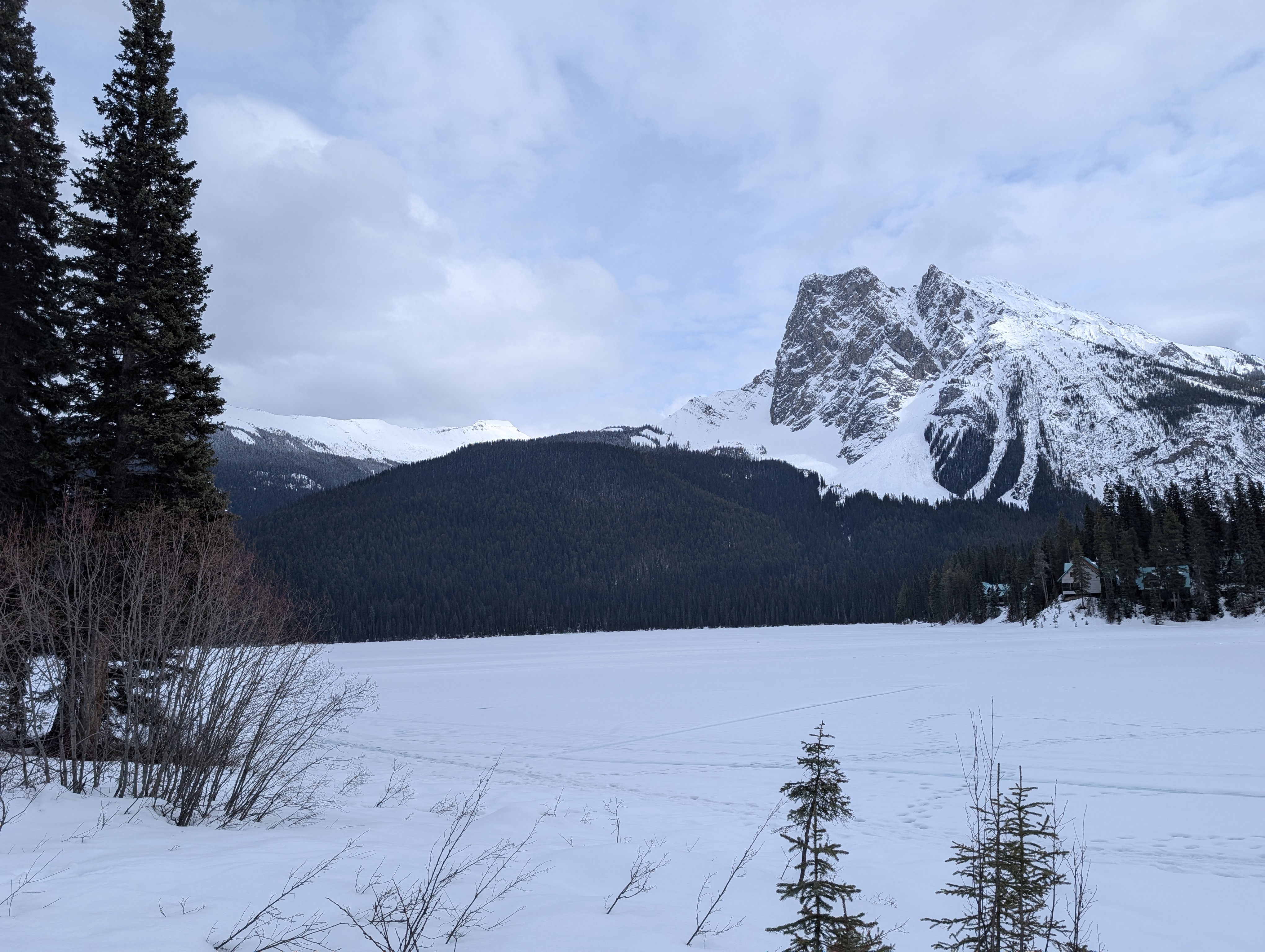
Day 2: Even though only 30 or so miles from Glacier, and in a (mostly) continuously mountainous environment, we took a lead from one of the locals we had met up on Youngs and went for the Tophat Traverse in Yoho NP to get a look at the snow over in the southern Rockies zone. Traverses are deinitely popular up in the Canadian rockies, and understandably so, usually the goal is to create a loop and go over a pass (usually ~10 miles, 4k feet of gain and some amazing views). The Tophat goes through a part of the Presidential group of mountains by Emerald Lake just north of Highway 1 in Yoho with the goal of cresting a pass by Mt Carnavan just northwest of the "Tophat" a little rock mesa on the ridgeline that resembles a top hat...

Looking accross the chunderball field at some amazing peaks

Showing off perfecct skimo technique, the huge squat step

The Tophat and Hamilton Lake

The Vaux massif across the highway
We set off at the blisteringly early time of 8:45 am, initally in the wrong direction towards Emerald Lake and our exit before turing around to go up the correct Hamilton Creek Trail. Before long we were hitting treeline crossing some large south facing slide paths that had recently gone big and pulled snow out to the ground. Up int he Hamilton Lake Basin we opted to dig a pit on a southerly aspect to see wha the snow was doing, as this area had many fewer reports and much less confidence in the snowpack. On this aspect the snow was beautiful corn, but instead of skiing down we continued on to the pass and dug a pit on a northeerly aspect aspect with a much deeper snowpack and some burried, but rounding, ffaceted layers. With some weather on the way we forewent a summit of the tophat (we were about 50 feet shy) and dropped into the upper Emerald river drainage, looking at about a 2500 ft continuous descent. The upper section skied well with nice light snow, if a bit weird with the flat light. Quickly, though, we entered the debris from the recent warming cycle. Here it seemed like the whole moutnain fell apart and large debris was everywhere that we had to navigate for another ~1800 feet of skiing, which was less than stellar but the setting was pretty cool. Southerlies were shedding and we saw near continuous rock and icefall off of a peak called the Vice President. Towards the bottom, things got touchy and the new snow transitioned from dry and skiable to wet and slabby. We carefully picked our way through to the valley bottom and found the (very untrafficked) trail that would take us eventually back to the car. I skate skied, but mike put his skins back on, probably the better option as the snow here was isothermal mank. Even though it was only about a mile and a half of generally downhill travel, the trip back to emerald lake seemed to take hours as travel through the dense forrest was difficult, made worse by the collapsing isothermal snow. Eventually, we made it back to Emerald lake and the well trafficked winter trails and somewhat quickly walked back to the car, another 7 hour and 30 minute day, but this time only 9 miles and 4300 feet of ascent, but with much more difficulty in snow travel. All in all a good day though in some tough snow conditioins.

Looking towards the Vice President

Some impressive walls