Showing posts with label San Juan River. Show all posts

Tuesday, January 30, 2024

Lower San Juan Friendsgiving

Far from the busy river of alte spring and early summer when it is running high, the San Juan on the cusp of winter is a quiet place. 

After the constant pressure and business of getting married (Yay! but also Yay it is over!) Lindsay and i wanted to get away for a long weekend. Thanksgiving was the obvious choice. We called in a small collection of friends and family to join and before we knew it we had ourselves a proper friendsgiving weekend getaway! Unfortunately, this time of year weather can be fickle in the desert. Throw in the fact that we would be in boats and that complicated things. Several days before we set out, weather models changed and suggested that a major storm would be cruising through right when we would be in the thick of things in the canyon. Things were surely going to get exciting.

Another Stellar Sunrise at Sandthrax camp

We set off from Salt Lake wendesday after work, a contingent from phoenix did the same. We camped, as we often do when heading to this part of the state late after work, at the Sandthrax site, which seems to be getting busier every year and, even with below freezing temps and a storm in the forecast, there were several others already there when we arrived. A short and cold night ended with a beautiful sunrise and we were off continuing south. The drive south of Hanksville to Cedar mesa has to be one of my favorite in the state, the views are spectacular and it is an area that still seems to have a semblance of solitude. After a quick drop of a car at the clay hills crossing ramp, we went back around to Mexican hat. 3 years earlier we finished a winter float of the san juan in mexican hat; it was nice to return and i (and i am sure andrew and lindsay as well) was eager to see what lay down river. 

Under grey  skies, we set off on the river and within minutes came to gypsum creek, our first rapid. At the water levels we saw, all rapids we encountered were no more than class 2 and were all short and straight forward. At gypsum creek we scouted on the left, walking across the drying bed of gypsum creek proper which was telling the story of this land. The drying but not fully dried clay does an excellent job of capturing footprints in amazing detail.

The Desert has a story to tell

As we left town, the canyon walls gradually rose around us; i was having flashbacks to the section just upstream 3 years earlier as they were remarkably similar. The lower san juan quickly enters entrenched meanders, at the far end of the first of these, the mendenhall loop, we took a quick warm up break to hike up to the mendenhall cabin. What a place that would have been to try and eek out a living! We stopped for the day a few miles further at the Tabernacle and set up for our feast. Feast we did! After getting the fire going we warmed our turkey in the coals, and enjoyed a proper thanksgiving with our small group of friends and family taking in tangerine sunset. 

Preparing for a Thanksgiving Feast under the Tangerine Sky

Thanksgiving Turkey warming up

Black friday was expected to be a dark and dismal day for us. Rain and/or snow was in the forecast, and not just a little of it. When we awoke, thoguh, we were greated to broken skies and the occasional blue patches! Down river, we had our first and only wildlife sighting, a big horn sheep that was running up on a broken ledge alongside us as we went down river. Around our lunch break the weather changed and a driving rain came in intermixed with heavy up and down canyon winds. After pushing through the rain and wind for 4 hours, we finally called it for the day at Ross rapid camp. Coincidentally, things cleared up and the blue sky and sun grazed us to close out the day. At Ross camp the chert and jasper intrusions are particularly prevelant. We explored a bit, finding the memorial to Mr Ross himself, as well as a small structure, likely a somewhat recently constructed hunting blind made when newcomers began to mine the area. As the sun set, the moon rose to perfectly clear skies, painting a scene on the canyon walls and seemingly hinting at better weather to come. 

The locals letting us hang out in the water as they watch from above

Clear Skies and fast water make a happy Lindsay

Exploring (and maybe yelling at the sun to sun more?)

A look up and down river at Ross Camp

Moonrise at Ross

Although winter canyons can be amazing for the solitude they allow, the deep walls, now ~1000 feet above us, and the east-west nature of the canyon meant that sunlight was a rarity, and on the occasion that we got to glimpse some, all would stop and bask in it as long as possible. Leaving Ross camp, we had just come into the sun and the temps had peaked above freezing again, but once on the water we were immediately back in the icebox. Even with the cold and a now constant upwind draft, the clarity in the desert post rainstorm was on full display and the canyon seemed so vibrant. At around 2 we arrived at the fabled Government Rapid, supposidly the "big one". Being potentially overly cautious, we stopped well above the rapid and walked the canyon down to scout. What was supposed to be a somewhat long and difficult Class 3 really was just two drops in quick succession, no more than 2+ at this flow, a straightforeward run down the middle or maybe a slightly more interesting run on the left. We had been leapfrogging another party that had put in shortly before us on thanksgiving, and we managed to catch them just as we were finishing up running all of the boats through government. At Slickhorn B we pulled over for the night. I doubted that we would actually see much sign of the oil exploration that had happened in the area other than some old equipment, but at times the smell of fuel oil was strong hinting that some of the natural seeps were still active. 

Old Man Beer Belly Spire reflected off interesting pools in Slickhorn

Early Morning Calm at slickhorn

Pancakes in bed, a river trip special

The crew getting ready as andrew plays his brain bongo

Tristan, ready to own another day of paddling on his first river trip in his packraft

At Slickhorn the water gets continuously slower. It was tough leacing the pace of this bend in the river in the morning, especially since we had the pleasure of frozen shoes to look foreward to. An hour or so after setting off, we made a stop at Grand Gulch to get out and get some blood flowing. The lower bits of grand gulch hold some pretty amazing pools sheltered under ledges. Some day we will come back and pack out grand gulch, the trip i had initially hoped to do but we didnt have time for. After Grand Gulch the effects of the Dam are particularly apparent. The river channel is 30+ feet above where it used to be, and as a result slowly meanders back and forth covering the entire bottom of the canyon causing consistent frustration. At Oljeto Wash we stopped again to go for a walk. This canyon was probably my favorite of all of the side canyons we explored but was guarded by a fair but of muck and quicksand/mud. We found petrified wood, interesting sand flows, and even some formed smokey quartz from an age long past in the canyon bottom.

Walking along the ledge that used to be a waterfall down to the river, Grand Gulch

Pools in the lower reaches of Grand Gulch

Walking under the overhang, Oljeto wash
Lindsay, the strong and independant woman that she is, singlehandedly holding the world up, you can thank her for not letting it fall over everyone. 

At Steer Gulch we stopped for our final evening. I had heard that there was a horrendous mud flat to walk across at Steer Gulch to access camping, but the upper entrance wasnt too bad. Andrew had committed a little too far down river and ended up breaking a paddle blade off trying to get back to the camp, but in the process found the preferred entrance among the tamarisk with some good flow to immediately step into. Steer Gulch was also my favorite camp, very close and intimate with the Wingate walls keeping close company. That night we had a ceremony for andrews fallen friend and granted him first ever use of our spare paddle that had come on so many rivers without ever seeing action. As the fire raged and our shadows danced on the walls, the night grew deep and cold and we eventually retired to sleeping bags under the open sky.

A raging ceremonial fire on our last night
Lindsays and shadows dancing in tandem

Morning on our final day greeted us with sunlight and a lack of wind that we had battled the prior few days. We slowly left behind the canyon walls and emerged back at Clay Hills where we were the only car in the lot, leaving the river behind to have some time to itself before hustle of the next runoff season.

Is it a river or is it a lake? The lower San Juan as we approach the takeout, most of the water is less than an inch deep with a channel in there somewhere...
Leeaving the Canyon Behind
Back at Clay Hills after a lovely long weekend

Friday, February 11, 2022

Winter water

 With the pandemic continuing into its third year, i have found myself in airports less waiting for late airplanes, and thus haven't had as much time to designate for writing. This winter has been less than stelar when it comes to actual winter activities, that is until last week's storms. We have had a thin and dangerous snowpack with historic numbers of accidents, and for me personally a new low in terms of number of days skied. Instead of skiing, we have been trying to think outside of the box. Winter river permits are extremely easy to get so why not pull the trigger on one of those? 

Virgin- May '20

A river that rarely flows, with Covid still fresh and scary, we took a weekend to get away and float a river in southwest Utah in to Arizona. Andrew, of course, was invited and came even though it felt like we were cheating on the rules a bit. Separate tent sites, masks and open windows while together, and not sharing anything were our strategies to try and stay safe. In this case, we floated the Bloomington gorge as a day trip, starting in Bloomington and running across the state line into Arizona. 

Its a fun class 2 run, mostly swift and flat with some sand induced waves. In town, the river goes over a natural river wide pourover termed "the waterfall" by some lady walking a baby in a carriage, the river eventually leaves town and enters the gorge, a pretty but muted and smaller version of the grand canyon. Towards the end of the trip there is a river wide fish weir, a 6 foot low head dam. There was a giant cottonwood that had seemingly been circulating in the hole downstream forever. We portaged but did witness one group manage to run the dam in a ducky, impressive! All to soon, the river passes under an I-15 bridge where we had a car stashed, our take out. I look forward to going back at some point to float the remainder of the canyon, the Virgin River Gorge. 

San Juan- a lonely river this time of year in a lonely corner of the state. Feb '21

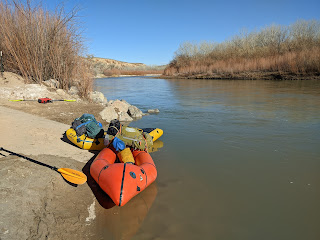
Usually a busy river, especially "when it is flowing", users need a lottery permit and have to reserve camp sites. With temps below freezing every night we snagged a permit without issue and didnt see another person on the river, exactly how i prefer it. 

Andrew was coming up from California and with the prospect of mediocre snow, we went for the San Juan instead, targeting a 3 day trip from Sand Island to Mexican Hat. Sarah was a last minute addition as well, we all planned on meeting in the afternoon in Bluff, Utah, the nearest town. Bluff, and a few other towns in the area, eptiomize the modern american rural southwest: mostly a sleeping and dying town except for the few tourist "eco" hotels of the like that an insta-influencer would rave about in super artificial videos on their channels; a few old gas stations, and, interestingly, a tesla charging station.

Instead of putting directly in, we went to check out some petroglyphs at the putin area, a worthwhile diversion as we got to see a kokopelli with quite the package.

After some frantic gear shuffling, trying to decide on layers because i couldnt decide if it was cold or hot out, and some discussion about how to inflate a packraft (this would be sarah's first packrafting trip) we finally got going. Not another soul around on the river, and with no other cars in the lot, we had our pick of the campsites. Because it was late we only did a few miles that evening, deciding to camp at the river house ruin campsite which we would check out in the morning. We put up the beloved circus tent that we would all share, got a fire going and shared stories, played games, and passed the whiskey around.

The next morning we got up at the crack of 8, which was around sunrise in this canyon, and went off to check out the river house. It is a really interesting ruin, i can see how it would have been a desirable site for a winter home (it is sheltered and recieves the first warming light in the morning). Before long we were off again, our destination: down into the Raplee anticline, past a few rapids, to a camp on the other side. 

There were more unmarked riffles than expected, but none that posed any sort of difficulty, we quickly passed through the rocky cliff gates into the deep anticline canyon and found a beautiful perch up in the sun for lunch. 


With the prospect of weather and increasing clouds, we called lunch short and got started again, with a goal of getting out of the deepest part of the canyon to catch early morning sun the following morning.

This stretch of the canyon was fast but mellow and absoutly beautiful in a deep canyon, with more beautful views around every bend. As the sun was getting low, and with the prospect of a camp a bit more than a mile away, just ouside of the canyon, i sent Andrew and Sarah ahead to get camp started while lindsay took a moment to relieve herself. Unfortuately, something was lost in translation, and as lindsay and i emerged from the canyon expecting to find  a roaring fire, we found nothing. Shit. We kept going another half mile past the defined stop site, still nothing. I got out of my boat and ran up one of the banks to get a higher view point, still nothing. We kept on a bit farther. At this point the sun had set and twilight was running out. I ran back up a bank again, blowing my whistle trying to find some sign that someone was around. Nothing. Lindsay and i started making backup plans. We would bivy next to the river, we had enough gear to stay warm. There is a road that parallels the river for this strech, once we get set up i will jog up and down the road to see if i can find anyone. Hopefully worst case they will notice the take out in the morning if we still havent made contact.

Then, lindsay notices some strange shapes off in the distance in the fading light. Is it a... dog? sheep? Turns out, it was a dry bag that was moving about on the shore, lets go check it out! lo and behold, our missing paddlers had overshot the last .5 miles to our desired campsite by 2 extra miles and had finally pulled off on the side to start to camp. When we pull up, andrew is working on getting soem firewood but i notice that sarah is cold, borderline hypothermic at this point, and i know that lindsay isnt far behind. We focus on getting both of them dry and warm, warm drinks and a nice fire. Eventually, the dust starts to settle and we debrief a bit over the fire. I should not have suggested they go ahead, i was hoping they would have a fire ready for lindsay when we got to camp, who was cold before the whole episode, only to elongate the risk by having all of us split up and out in the cold on the river until after sunset. Sarah was the percieved "leader" among andrew and sarah, but she was very cold to hypothermic and was not thinking straight. Definitely good learning but a very avoidable situation that could definitely have been worse.

In the morning, i wake up to roam around, i had noticed the night before we were at "sulfur springs". I wanted to find the spring! Navigating around the beach i eventually found the outlet for the spring, quite sulfurous indeed. Following it up, the spring emerged from an unexpected crack high up and a fair amount of plant growth seems to be thriving despite the sulfur. We dust off the night before with pancakes and a warming sun. A few more miles floating by mexican hat rock delivers us to our take out in Mexican Hat. After a quick gear sort, with a few more hours in the day, we decided to go explore a bit more of Cedar Mesa before heading back to SLC. We will be back!

Other Notables: Gren river through Grey canyon- A nice and easy float that we did a few times, among them while filming for Adventure Scientists as we collect water quality data for land managers, and rivers up in washington of course! And a very miserable failed atttempt on a very dirty jordan river near home, we hardly made it a half mile before bailing on this sad strech of water. Too bad because we were hoping for a bike to and from the house river trip but it didnt work out.