The theme of late season float trips for 2024 turned out to be Dinosaur NM. This part of the west has long been a black hole for me; I have been thinking about getting to this part of the west for a while but for one reason or another never made it. At the beginning of the year, i was lucky enough to pull a Yampa permit for late fall, and, when thinking about what to do for a long weekend in august, we settled on the stretch below Flaming Gorge dam.
Land of 10000 Trout
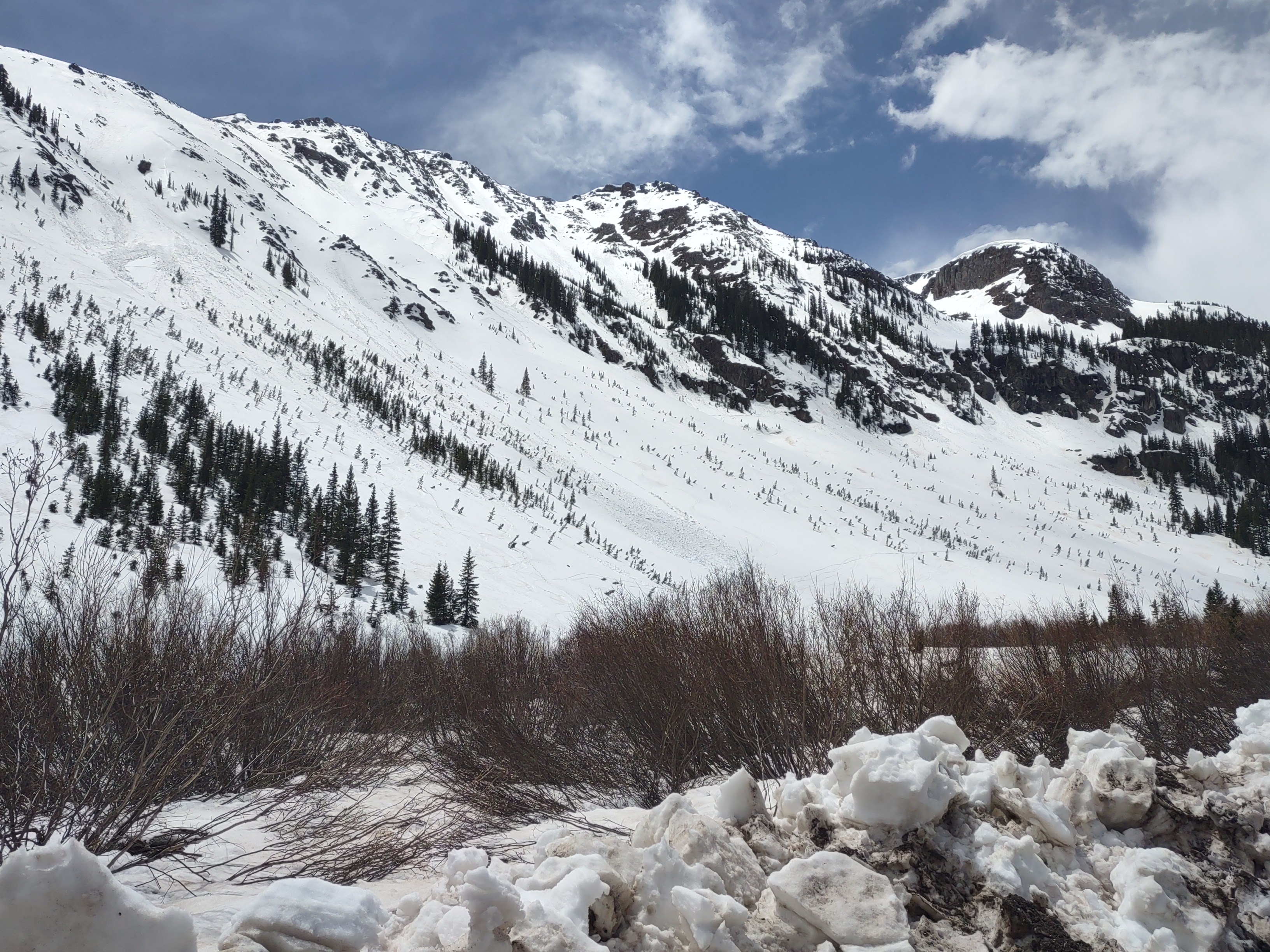
The stretch below Flaming Gorge is beautiful, if very unnatural. The water is crystal clear and the gorge is amazingly beautiful, but man that boat ramp may be the most busy boatramp anywhere. That is probably why i have avoided it for so long, well that and the non-reservable campsites that are notorious for getting poached. Nonetheless, in an effort to get everyone together for a short weekend trip, i booked a site and we set off. As with many other locations, the laws still haven't come around to the idea of packrafts. Per the rules, we would need to have all boats inflated to drive down and use a ramp. Oh well... When we did finally get on the water the canyon beauty definitely was on display. We cruised through the A section pretty quickly, looking to get to our grasshopper site. Really, one could easily do the A/B sections in a day, but stopping at grasshopper (next time I would stop at trails end or tree tops instead) gave us plenty of time to hang out, fish, go for a swim and have a fire to introduce a few new people to river trips. Our day 2 started off a bit stormy, but we still were able to get out of camp by 10 or so. In a bit of a rush, we really only stopped at Red Creek for scouting. Red Creek goes pretty easily for packrafts on the left at class 2, but on the right there were a series of big waves/holes that were more class 3. Two of us ran the class three option, and I ended up flipping in my new refuge, it definitely floats quite a bit shorter than the expedition.We tried to hurry, battling slower water and the ubiquitous headwind, to get to the takeout and get some people off on their way to the airport. A bit rushed but nonetheless great for a weekend!
Late Season Yampa


The Yampa, what a river! Sure we didnt see it in its swollen spring runoff glory, but in fall, it sure was a treat to see this naturally flowing watercourse. After a bit of a whirlwind of prep, i was coming directly off a conference and some extensive car maintenance and prepping for a conference immediately after the trip, with others in various work crunches of their own (Unfortunately work seems to be taking over all of our lives these days, hopefully some day we can find that fabled balance that is always sought), we set off for the Yampa from our various states. The "OG" crew, Davis+Jennifer, Lindsay + me, and Andrew all met up at a very dark Split Mountain boat ramp to shuffle into a single car to head off to the put in at Deerlodge CG in Colorado. I am glad we didnt get to see the beauty of the takeout area because it turned out to be a treat to come back to but more on that later.
Night zero was a cold one, we woke up to temps in the low 20s and elk bugling off in the distance (with all manner of animals making their noises the night before). Unsurprisingly, we were the only ones looking to put in, and the only other group at the campground quickly packed up and left (probably hunting?). I was a little apprehensive because we never got the official blessing from Dinosaur NM to float as an unsupported packraft crew (their regulations require a support craft for all packraft or SUP trips? alongside the most extensive list of redundant equipment i have yet seen). Ultimately, no ranger showed up and we put in at a bit after 10:30 am.
Day one: Familiar but diffferent. On the river started flat and wide (we had flows between 330 and 370CFS), but luckily not much in the way of walking as the channel was mostly able to be found. Within about 20 minutes we had passed through the anticline and into the Yampa river canyon.
In general our experience on the yampa was characterized by 4 different sections: Above the canyon the river was wide but moving at ~2.5 mph. The canyon through Big Joe rapid was mostly boatable with the occasional need to walk due to wide spreading flow and a lot of rocks in the channel with lots of boat scraping (an extra 100+CFS would have made this stretch perfect) with easy rapids, below the outflow for big joe the river heavily alternated between swifter rapid sections (nothing harder than warm springs which was maybe 2+) and long stretches of deeply pooled flat water with almost no flow but also no scraping.


The goal for day one was to get to Teepee camp/rapid. We were fresh, and with the river being somewhat steep, we were able to make it to teepee by lunch. Here, after some discussions, we pushed on, shooting for Big Joe camp to allow for shorter days further down canyon where we could explore a bit more. Teepee, our first "major" rapid, was more or less a rock dodge for the main part of the rapid. It is obvious that spring floods push the side canyon debris relatively well, as the mile and a half or so below each rapid was wide and shallow and peppered with large rocks making scraping an inevitability. A surprising moment of joy was seeing all of the large beautiful ponderosa living in the river channel, something i feel we dont see too much with our desert river exploits. Much of this stretch below Teepee was very reminiscent of the San Juan, simultaneously familiar and yet new. Mid afternoon we saw our first group of bighorn sheep, who are often mentioned in all of the put in signage for floats we do but are almost never seen. I guess the benefit of now sustained flow is that this canyon has the majority of the year to be without humans, it was nice to see a more "wild" stretch with so much fauna out and about. The longer the day went on, the lower the sun. Eventually we found ourselves on miles long stretches staring directly into the sun trying to dodge rocks in the channel. Right around sunset we finally made it to big joe camp. Big joe is a nice camp with lots of space up off the river under some trees. One of the benefits of doing late season trips is that the tribe gets together for a few hours around the fire every night. Also, the stars! we had a few nights of clear weather and, being so far from any major city, this was an excellent area for seeing the milky way.
Day 2: Big Rocks and wide channels. Just before setting off down big joe (or first "class 3") we got some sunlight at camp to warm up a bit. I also took a brief jog up Starvation Valley, the canyon behind camp. Its a constant lament, but i wish i had more time to explore these areas, starvation valley looks like it holds some interesting treasures, including a potentially interesting cave, just close enough to draw my curiosity but too far for me to tell if it was just a shallow alcove or if it held something interesting, but alas we had to get going downriver. Big Joe, at this level, is really just a few rocks in the channel you need to dodge. We went left of the main boulder which lined up for an easy outrun.


Just Downstream the Weber Sandstone, the main event geologic layer of our trip, made its first real appearance high up on the walls. All at once, the river stopped its straight dive west and began to heavily meander, entrenched in the sandstone above. The river slowed down and we were met with long sections of glass, perfectly reflecting the golds, tans, reds and greens of the canyons above. Rounding into Harding Hole, a perfect flat and open park after a long journey down a deep canyon. Harding Hole camps look great and the idea to hike to the rim was attractive, however because they are very sheltered, they would be very cold this time of year. A pair of hikers had descended the trail from the rim and saw us passing on the river as they camped at harding 4. We did stop briefly at Signiature cave, something i thought would be kinda lame but the cave was unexpectedly large and deep, with a few older petroglyphs and many newer "signiatures" some unfortunately scratched right overtop of the older artwork.


Downstream, we came to the Grand Overhang- a point as dramatic as any on this or any river we have seen. The cliff overhangs the river and rises some thousand feet above the riverbed. Pretty cool stuff. Downstream is a mini- grand overhang at Mathers Hole, a camp that i had initially booked for us. It looks like a really cool site but we were hoping to push ahead a bit more, maybe we will try to stop there next time round. Downstream of Mathers hole we hit a very long stretch of flat water above the private ranch. Before the wind kicked up i managed to snag a few nice shots of the scenery but shortly thereafter we entered the gring, trying to get through the flats and to camp. Just after the Mantle Ranch there is another archeological site that i wanted to hit. Looking at the map, we stopped somewhere in the middle of the river, as if i needed more reminder that we were at low water. Finding the trail up to the bench was tough because it was hard to tell where people would land at higher water. The site itself was pretty cool, another deep alcove with the remnants of a bunch of graneries and some rock art, plus we were able to see some outstanding cottonwood colors juxtaposed against the grey rock. Camp that evening was a short ways downstream at Laddie Park 1. Note for next time, bring some climbing gear! The wall above camp held some of the best looking routes thusfar, a few splitters that went several hundred feet up, plus a few potential pocketed sport routes up the large huecos that linked almost the entire wall, very unusual for sandstone. Laddie also had some great tree alcoves with some nice meadows in between, definitely the preferred of the two as laddie two was just juniper. That evening at camp we celebrated river life with crackerless smores and "scary" stories that lindsay had brought along that were great for some laughs.


Day 3: The last of the Yampa. Tiger wall came all to quickly after leaving camp. The consensus was, although the grand overhang was grand, it was so grand that you felt disconnected. Tiger wall, still easily a few hundred feet tall but with some namesake black streaks, garnered more awe. Its hard to say why. Downstream the yampa really began to sing in its full glory; the walls rose to sweeping sanstone flanks hundreds to thousands of feet tall and resonated like few canyons do. The water was placid but moving and as we sang, the canyon returned our notes fourfold. Not too far later, a young bald eagle looked down on us from a high wall with curiousity, surely wondering what these river things were doing making so much noise. All too quickly, the placid waters came to a halt above Warm Springs rapid, in theory the hardest of our trip, typically a class 4 but at this low water it was farily straight forward 2+ that drops in two major stages. The entry is pretty simple, then after running generally left of center through the middle, i ran right of the major rocks on the final drop out, pretty straight forward but probably a whole different animal at high water. Downstream of the magnificant warm springs cliff is a section i termed in my head as rockfall alley; every few hundred feet the sides of the canyon were swept clear of growth into rockfall chutes. While nothing happened while we were there, a few of the chutes looked like they have been active recently. Shortly before the green confluence was sand canyon, probably the biggest miss of our trip was not exploring up that canyon, definitely something to do next time. One more pitstop before the push to camp in whirlpool canyon, we stoped at the toe of Steamboat rock to check out some more rockart, and in my case, discover an old layton kor route up a steep set of shallow changing corners that looked amazing. Standing up above the confluence, it was cool to see the mixing of waters, the green coming in crystal clear from the dam, and the yampa coming in heavy with silt as it is free flowing.


Whirlpool canyon starts abruptly, to put it lightly. The dark depths of this canyon contrasted the yampa starkly, i can see why Powell did not look lightly on this canyon after their fiascos in Lodore, it seems like some difficulties await downstream. Luckily, it was mostly just good (looking) riverside climbing (we didnt have time to actually climb) with some consistent if small pool-drop rapids. The push to jones hole was tough, we were loosing light and the group was tired from a few long days on the river. We were hoping that Monday would be short and allow for a solid side hike up jones hole. Finally, just as the sun seemed to finally begoing down, we came upon Jones 1, and we grabbed the first spot we found. Jones probably had the worst landing of all the camps we had used thusfar, a mucky slow pool somewhat far from the flow, but that might be different at higher water (jones 2 looked much better, but hindsight is always clear). Really, all of the jones sites looked stellar, in some low box elder and cottonwood forrests, and jones creek looks like a true gem of a creek in the desert.

Day 4: The weather moves in. What was looking to be a large storm moving in on tuesday, our last day, became a forecast for a bit of a dreary rainy day with the prospect of paddling in snow on Tuesday. The group came together and decided to forgo our hike (which would have been in the rain) and instead get up and out early so we could run the final 18 miles to the takeout on monday and avoid paddling in the windy snow on tuesday. After packing up in the rain, whirlpool ended as abruptly as it started and we were out into island park. The river so dramatically transitions into wide open and braided fromt eh deep narrow canyons that we had been enjoying for the past few days. After gettting through Island, then Rainbow parks (with some group difficulties, splitting the group never goes well), we stopped for a group circle up at the Rainbow park boat ramp for lunch. In general the group was feeling good enough to send it through the final canyon which would also hold the biggest/ hardest water of the trip. Lindsay opted to hang at the boat ramp because she wasnt feeling well, and i could come get her with the car when we got to the split mountain ramp. Coincidentally, just as we started in to split mountain the skies parted and the sun came out. Split mountain was a true gem, i wish that it was legal to camp because there were so many areas that looked amazing and i would have loved to spend more time. SOB turned out to be the hardest whitewater of the trip, a series of waves and holes with an interesting right to left side of the river transition mid rapid interestingly, Schoolboy held much larger waves than anything else and caught us a bit off guard because of its 2 rating. The end of split mountain is also stellar, as the weber comes back to river level then abruptly dives under the surface right at the boatramp, decorated with the best cottonwood groves of the trip. At the Split mountain CG we enjoyed one last campfire and hashed out some group baggage. These trips are great fun but also are a great way that we can all grow together and we hashed through some of that with the safety of knowing that there was no more risk in our trip.


Day 5: Dinos! Because we had finished so early, we took a group excursion to explore the Dino NM visitor center. Wow! it was really cool to see so much in such a concentrated area. These layers are quite familiar as we have been through them (morrison, mancos, etc) on so many other trips, but in this area there is such a concentration of bones, it was a treat to see them protected for the future, rather than just extracted and sold of, as would have happened without a NM and as has more or less happened at Petrified Forrest. The drive home was sporty as we drove through the storm we were trying to avoid, but we made it; and i immediately turned around and went back to the airport for another work trip.