Monday, September 2, 2024

NZland

 This summer, after so many years of wanting to make it down to the land that inspired the Lord of the Rings films to be created, Lindsay and i made the trip down south. For me, this was an inevitibility just like arctic Alaska; New Zealand was a place i had never been to but i knew it was a place that, once i visited, i would not be able to leave easily and i would long to return to, and I think for Lindsay it was the same. Its been more than month since we got on a plane to leave, Bali bound at the time, and we both cant help but think, almost daily, about picking up and moving South. 

The trip was a bit of a whirlwind, we had 2 weeks to travel both islands. Not nearly enough time, however i dont know that i would ever have enough time to go everywhere and do everthing i wanted to. 

A lonely beach at sunrise

We did get to experience a few wild slivers of New Zealand, though.

On a solo mission that Lindsay graciously volunteered to shuttle for, I got to run the Tongariro Alpine Crossing, supposedly one of the best treks in the world, or so the signs said. The signs also were adamant that I was doing the route backwards, but that's ok. An hour before dawn (which is nice and late in midwinter at 830 or so) I set off from the northern trailhead, off into the dark forest that immediately made me think I was more in Jurassic Park than Lord of the Rings; I was constantly looking back over my shoulder to make sure there wasn't a velocirapter hot on my tail. Luckily, the islands have no large natural predators and I had nothing to fear. 

Sunrise Looking north over the High Lakes region just north of Tongariro National Park, North Island

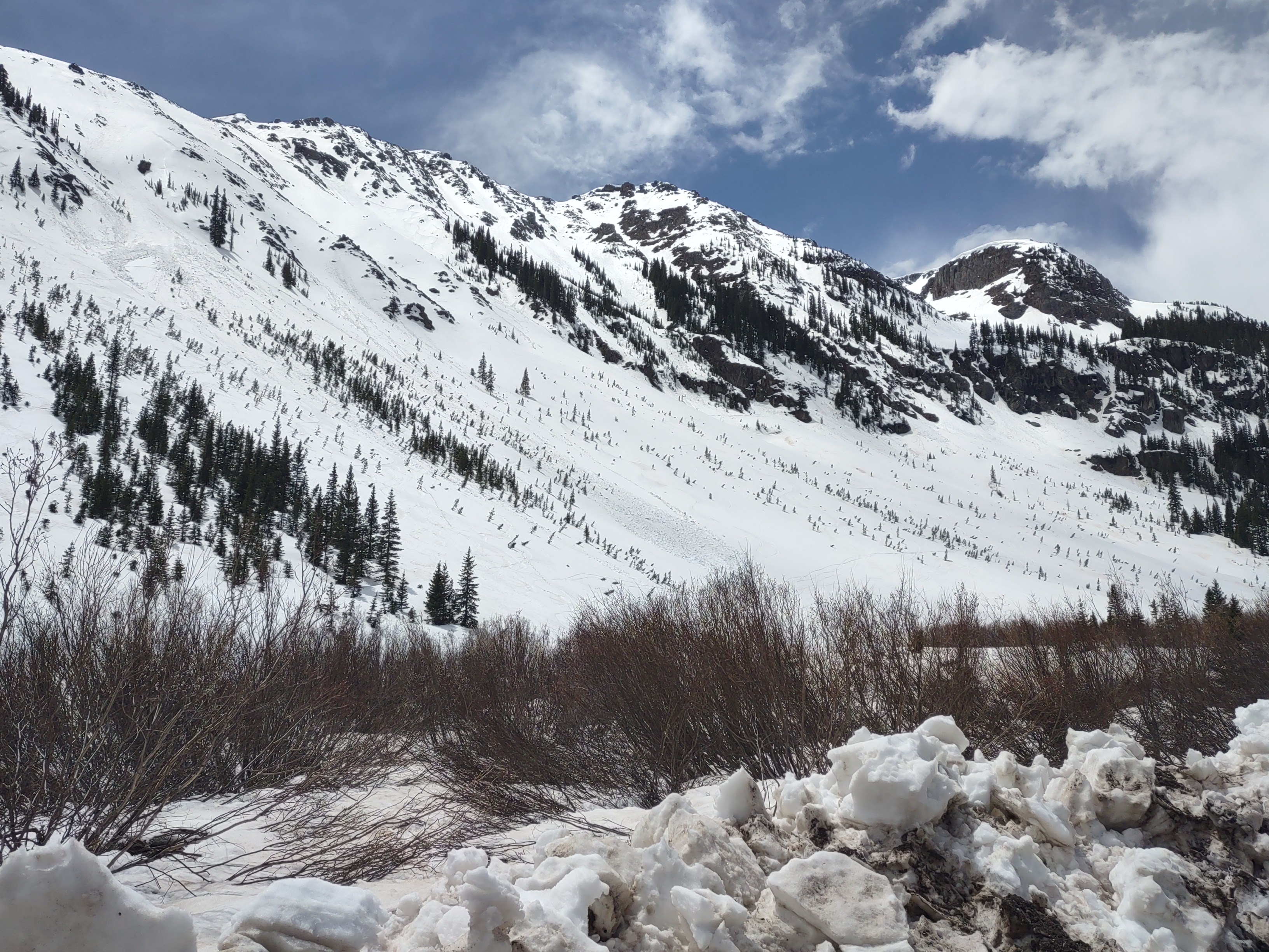
At dawn I emerged from the thick primordial forest into the alpine. The alpine zone in New Zealand, though, starts at like 2-3.5k feet above sea level, a bit of an oddity for me coming from the States where we have conifers that can better withstand the weather (fun fact, NZ doesn't have any native alpine zone pine/conifer trees outside of a juniper and a cedar). Looking uphill, I had a few thousand feet of climbing where I would gradually leave the tundra behind for raw volcanic rock. Looking off in the distance, however, there was a seemingly endless series of smaller forested mountains and lakes I was rising above. On the ascent, I passed some bathrooms, clearly a testament to how popular the route is, as they would have to be serviced by helicopter. The route itself is largely manufactured, in that it has a graded and stabilized surface, very unlike the rocky terrain we frequent here in Utah. Apparently at one time there was a mountain hut on my ascent, about an hour and a half out from the parking lot, but during an eruption in 2012 it was taken out by some flying debris, wild. Before long I had entered the true alpine zone, devoid of vegetation and covered lightly in snow. In the alpine zone there are a few beautiful lakes, some active hot springs and fumaroles, and a lot of loose volcanic sand, and views seemingly to the end of the earth (at least, to the end of the north Island, I could see other volcanoes off in the distance). 

Emerald Pools and Fumaroles on the Apline Crossing

Up and over the crest of the alpine crossing, as I was running on the slopes of mt Doom (My Ngauruhoe was used as mt Doom for any shots showing the mountain in it's entirety) I finally came across the beginning of the crowds that flock to this trail, all, conveniently, going the "correct direction". Funnily enough, because I was wearing my standard winter running gear, shorts and a sun hoody with some backup warm clothes in a pack, one of the trekking guides mistook me for another kiwi! Before long I had come to the end of the standard trail, however I had intended to connect for another 7 miles to the next volcano to the south where I would hopefully meet Lindsay on the trail so we could check out some waterfalls. The back 7 running was, well, subterranean. I am not sure I have ever seen a trail more washed out, and I understand why there was so much extensive work done to stabilize the popular section now. In this lesser used section of trail, I was often in a trench up to 20 feet deep and constantly navigating loose unstable mud slopes as I went the out the many drainages I needed to traverse to get to the whakapapa trailhead. Checking the map, Lindsay decided on a self care napping day instead of a walk, so, once I got to my final choice, head up to a waterfall and make my intended loop or head south to the trailhead, I cut it short to just 18 miles, I was behind schedule anyway and Lindsay and I had things to do! All in all it was a nice trail for the alpine crossing section, somewhat unique, but it just goes to underscore the beauty that Lindsay and I live in here in the intermountain west!

Crossing the Apex of the Tongariro Alpine Crossing

Mt Fuji? or Mt Doom? looking back at Mt Ngauruhoe

The following day, we set out from a campsite just west of where the alpine crossing was set, with out sites on the Tongariro River instead of the national Park. The river generally is boatable year round, according to some prior research, at least for packrafts. I had planned for Lindsay and I to float the access 14 section, sandwiched between two basalt gorges that both hold class 5 water. The run we were looking at should top out at a low and boney class 3 but had a (short and flat) basalt slot canyon of its own, plus the water! It was supposed to be one of the cleanest rivers in the world and home to a whio (blue duck) population, which is apparently relatively rare. The access 13 section did not disappoint. Also, while camping the night before, we were graced with kiwi presence, or, at least, a kiwi screaming somewhere near by in the forest.

A quick moment of Calm on the Tongariro Access 13 stretch

After a 4 mile or so hike through the forest at sunrise, we made our way down to the river just downstream of the tree trunk gorge, apparently the site of a few boater deaths due to narrowness,. hydraulics and the possibility for wedged trees. Right off the bat, the water stood out for us Colorado plateau boaters used water thicker than chocolate milk. The river was definitely lowwww. It had decent flow but the bed was chocked with a lot of large ish boulders which allowed just enough room to maneuver around. Coincidentally this was our first trip with our new refuges which paddle a fair bit smaller than the expeditions we are used to. That combined with the new continent shock plus the fact that we were paddling north (into the sun and Lindsay forgot her sunglasses) meant that Lindsay was on edge and way in her head about the float. 

a Whio or Blue Duck

Passing through the Pillars of Hercules

In general the water was somewhat unremarkable, just fun and consistent steep ish boulders dodging drops with short pools between, not too dissimilar to a lot of the muddy rivers we paddle in Utah. Lindsay ended up bottoming out a few times and getting stuck, and decided to walk a few rapids that she wasn't feeling. About a mile and a half in, we saw a blue duck (whio)! Apparently there are only about 3000 left so seeing one was definitely a treat. Then, we saw another, and another, then a pair sitting on a rock! All in all we saw maybe 6 of these good looking ducks. After a few more boulder bar drops (the last one was pretty steep! At least where I dropped it) we found ourselves at the pillars of Hercules, the short basalt slot that marked the start of the gorge section. It's really hard to describe how beautiful the water here was, it had maybe a slight blue-green to it but was just so clear! After a while longer of some interesting pool and drop rapids, we passed under the electric transmission lines, an obvious sign to get out lest we need to send it over the waterfall in the gorge below. Before packing up the boats, I convinced Lindsay to jump in with me to celebrate the beauty of the river! The hike out was exciting. Almost like a 5.2 climb with packs,  but climbing on holds made of dirt and tree roots, ascending a hidden stair that took us out of the he gorge and back to the road a short walk from our site. I ran off to grab the car and we set off for Wellington and the south Island.

Walking over to the low water channel on the Makarora

To give a quick review of the south Island, it was everything I thought it would be and we didn't have nearly enough time. I shifted some of our plans around a fair bit due to weather and water conditions, originally thinking about floating in the whitewater hotspot of Murchison, then moving on to try the hāwea (which was at highest floor stage) until we finally settled on driving into the southern alps to run an all to short section of the Makarora. This was where we first met the new Zealand biting black fly, that, although it was winter, was still very much so active. The views were so worth it though, and the water here had all the clarity (and tons of huge trout) that the Tongariro had, but with more of a sapphire hue. A fair bit easier, the Makarora is a short 3 miles of class 2 boating. Conveniently, the main attraction in the area, the blue pools, were closed to foot traffic because the bridges were out of service. Luckily, with boats, we could still access them, and just wow, the color and clarity is just something else. The pools seem like they should be at a tropical beach, not the near-alpine in New Zealand with near freezing water temps. All too quickly we saw our white behemoth on the side of the highway indicating our take out and just about the end of our New Zealand trip.

About to take out on the Makarora

We did get a day of mediocre skiing in at the remarkables (maybe they are more remarkable with more snow) before moving on to Bali and a wedding followed by sickness that soured the end of the trip. I can't wait to go back and get more into the mountains and backcountry of the south island which definitely lived up to the hype. 

Monday, June 3, 2024

Spring Strike Missions in the San Juans

Its been a while since i have been on a proper ski trip. Longer than i would like. I guess lately most longer trips have involved boats and whitewater, i think i was just stuck in that cycle last year. Mike managed to lift me out of it this year after the prospects of an AK trip fell through. Instead we set sights on the San Juan range, somewhere i have long thought about skiing (especially last year when andrew and i floated the upper Dolores starting in Rico). A late season storm shifted plans a bit and pushed back timelines but we found ourselves setting out on the 28th with sights set first on the Telluride area. 

San Juoaqin Chute

An asthetic line for sure. Its not often that you get a laser straight and deeply incut chute but when you do its bound to be a classic. Set in the backcountry and accessed most easily from telluride, i am sure this one gets skied somewhat often, especially with how visible it is from the resort, but nonetheless it was quite the outing. After a 4 am wake up we drove up to mountain village at Tellurise (not a whole lot of good options for late night/early morning parking...) and set out around 5:30. The 4k or so gain up telluride went quickly (although the snow levels were a bit higher than we had hoped). We made our way to "See Forever" and followed that to the top of the resort, then out the backcountry gate. A quick descent navigating some cliffs left us in the basin to thewest of the Chute where we transitioned back to skinning. We opted to skin around the back of the chute rather than boot straight up to minimize hazard. In short order we were on top of the chute where there is a rap station (not sure what this is for? maybe for ski patrol rescues...). Dropping in, mike did a quick ski cut and found stable powder! The chute proper is ~1k vert long, straight, and at the choke only maybe 15 feet wide, definitely a classic! From here we took a gradual bench to reassend (the sun came out and things got HOT FAST) and went back down more or less the way we came up, done by a bit after noon, too easy! We went into town for a bite to eat before moving south out towards Lizard head pass. 


Mt Wilson +Box Car

Another 4 am wake up. Luckily we had snow consistently from the trailhead, which, given the early melt and snow conditions at Telluride, seemed like a bit of a blessing. We botched the approach a bit (following some previous ski tracks) and rather than traversing, added a few hundred feet of vert on both ends of our trip, maybe it was more direct, maybe not... EIther way, a bit after sunrise we were nearin the basin draining the east and northeast sides of Mt Wilson. It was beautiful and clear and we were hoping that the fresh snow would have corned a bit from the sun the day prior. Ultimately the ascent was fast, albiet hot in the sun. We opted to skin around the boxcar chute which descends skiers right of the east bowl through some large cliff bands. At around 10:30 we made the final short 100 ft ascent to the peak proper (its been a while since i have been on a peak like that, it was definitely a treat!) and downclimbed back to our gear (the top most part of the peak was not skiable). A quick ski through some heavy powder on the upper east face led to the chute entrance. After a bit of trepidation about the conditions in the couloir and how narrow the top was, Mike dropped in and quickly found that we were good to go! The snow was soft (if a bit heavy and wet, trending towards wetslide potential) so we pitched things out trying to get through safely and efficiently. Another gem! Its a shame that the couloir doesnt have more like the very bottom where it is deeply inset inbetween the cliffs, but the position was stellar! At the base we reversed course and followed our tracks out, managing to avoid the need to take skis off, although i am sure the snow broke up a day or two after our ascent. 

One of mikes friends who joined us for the ski went back to Glenwood and we set off for ouray and the other side of the range. We checked into a cabin and called for a rest day on wednesday before resuming skiing (largely based on some potential for weather that we didnt want to be out in).

Mt Potosi North Chute

Little did we know, the road was open almost to yankeeboy basin. On the drive up we were met with a dusting-2 inches of snow around the 9k mark. At the mine/road to yankee boy split we decided to call it and walk from there due to unknown road conditions and a desire to not get stuck/waste time messing with the truck. The ascent up the almost uncleared road (just a dusting of snow and ice) went quickly and at twilight we were looking up the base of the southwest face. The southern exposure of Potosi is full of a patchwork of cliffs, i had looked into going up the southeast face to the col with the north chute to prevent the need for a reascent, but having now been up there i think that route would likely have som etechnical scrambling and would likely be slower. The south facing shot we ascended was about 2k vert of fall like through a rocky choke, it looked like a decent ski line (and had some tracks from some one skiing it not too long ago). In the choke proper there was ice fall after ice fall, kinda makes me wish i would have brought my tools! most of the ice was pretty rotten at this point though but seems like it could be a cool place to get away from the crowds and climb (with some obvious avalanche hazard). At the coffepot col, we could finally see the line and it was in great shape! The easterly aspects were heating up though, so we quickly descended (one at a time due to slab potential) to the base of the chute and transitioned back to booting. 

On the ascent, the snow felt mostly stable and largely powdery. There were a few spots with some weird layers that we pitched out from safe zones, but nothing screamed danger and around 10:15 we had made it to the summit! For such a craggy peak, Potosi has a strangely flat and broad summit. After a quick transition i lead the pitch back to the col with the north chute. Mike sent it from there down into the chute and had some amazing powder turns. You cant beat 50 degree powder turns high in the alpine on a bluebird day! To get back out, we had to reascend to coffepot col which was now both looking warm and like it was starting to get wind loaded. I set off to start breaking the skinner while mike transitioned so we could pitch out the last climb and hop between safe zones. Once again, we were granted passage. Rather than descend back down what we came up (which was still looking very icy and unappealing) we continued up to the coffee pot rock to try and descend a bit further up canyon on a more open slope that might have warmed a bit. From coffee pot rock, there is still a maze of cliffs but we did manage to find a way down, finding a mixed bag of breakable crust, stiff sun crust, and finally, a bit of corn; this was a bit more of what i had expected to ski in colorado rather than powder, but the views were stellar! Before long we had made it back to yankeeboy (and the obvious turnaround that had been plowed out that we could have driven to). We had hoped to potentially do a line on stony mountain as well, but decided to call it due to the warming we were seeing. As it turns out, not parking up high worked to our advantage because we came across a sedan that was stuck on the road up... The guy was planning on taking his low clearance 2wd sedan up a 4x4 road and starting a snow climb at well past noon, solo (closer to 1pm at this point). Red flags all around. I spent some time coaching on how to get the car unstuck (it was wedged in on the nose and the drive tires had almost no load) while mike got his truck to extract. Once getting him unstuck we suggested that it might be a bit late for alpine objectives with avy hazard but i think the message fell on deaf ears. Oh well, we did what we could. From here we left the Ouray zone behind to head down to Silverton and meet up with some others in the hopes of doing a traverse. 

Mt Snowden Naked Lady

After grabing a bite in town in silverton (at seemingly the only place open, which was also actively under construction...) we drove around to look at conditions. This part of the range had considerably less snow down low and our hopes of doing the Turk-Sultan traverse were quickly quashed. Looking around, a few other potentials came and went, until we eventually settled on Mt snowden and a north facing bowl just to the north of it as a potential set of objectives. 

As with every other day, we started off at 4am, leaving our campsite to drive just past molas pass where we would start. The treck through the woods to the base went quickly- probably one of the easiest aproaches we had done yet in CO. The couloir itself looked a bit chopped up. Upon entering while booting up we did find an old booter but quickly learned the skiing wouldnt be quite as good as what we had on previous days. Nonetheless, the boot up the chute went quickly. About 3/4 of the way up there was a rock band that was only barely passable in the snow. We decided it was probably best to just downclimb back below that band due to snow conditions but wanted to hit the peak anyway. Outside of the chute, we found a small rock step on the trip to the top that wasnt overly difficult but had some exposure. It was cool to be able to look around each day and see the lines we had tagged on previous days, and this was no exception. From the top of Snowden we could pick out a few of the other peaks we had summited, even though a fair distance lays between each of our objectives. After a few minutes we turned around and downclimbed back below the rock band (downclimbing always seems to be the least secure) and skied the chute. It wasnt great skiing but the views were great! Once outside the chute we found a still bulletproof crust and opted to boot the short way back up to the north facing bowl we had been eyeing. From afar it looked like it went from the top, but from up close it seems we were a few days late and there was just enough exposed rock to not make it worth it. We donwlcimbed a bit to transition where things opened up. For whatever reason, the face was still holding excellent creamy snow! The upper bowl was definitely the highlight for the day. The traverse back out was a bit long but worth it to have gotten in a bit more powder. Back at the lake we had more or less started from, we saw another lone skier. Once again it was nearing 1pm and the skier was hoping to get on the Naked Lady... We communicated the conditions, and also that it was pretty late in the day to be starting up something like that, but once again... deaf ears. Hopefully he made it out. 

Chattanooga Zone

Looking for something that would offer a shorter approach to facilitate the drive home, we were debating between going back to yankeeboy and skiing Stoney Mt or trying a new zone. Ultimately we settled on a new zone- the Chattanooga area which was definitely the right choice. Kind of like a longer Emmas area in the wasatch, the Chattanooga zone is roadside and has a ton of ~35-50 degree lines between 1 and 2k long that drop straight back to the car. We did two laps, finding a bit of corn and some still frozen icy death sheet on the first lap. Good times were had all around! We bailed for the drive home right as weather started to move in. All in all it was a great and successful trip! Definitely a lot to ski in the San Juans and i am sure i will be back! Thanks to mike for getting the ball rolling on this one!


Monday, May 13, 2024

Salt

 Years ago, long before i had touched a packraft, back when the idea of getting a raft was a faint glimmer on my horizon and i was instead looking at getting specialized packrafts specifically for canyoneering in the grand canyon, i would look upcanyon from the highway 288 bridge on my way up to the Sierra Ancha range wondering what mysteries were upstream. 

I looked into the float briefly after i bought my first packraft but was quickly deterred by the class 4 rapids in the stretch and the aura that remained around quartzite falls which is currently a mere shadow of its former self. It has long been in the back of my mind as something i wanted to work up to, another in the line of progression of permitted western rivers that Andrew, Lindsay and i had slowly been working through. In fact, this year i decided to start upping my permit game and had applied for both a Deso and a Yampa permit, but only managed to pick up a yampa once things were openly released.

 In February of this year, a friend of a friend put out the call, the salt had enough flow to be boatable and a permit had been drawn, plus several that were going on the trip had run it a few times before. A last minute flight was booked and before we knew it, we were in the van driving out to the Salt River canyon!

Looking downstream at the put in. What mysteries lie around that bend?

The crew for this trip was a bit more of a hodge podge than our usual, with a dedicated core and a few newcomers. Instead, we had a collection of those that could make the short timeline work, thanks to the lottery for incentivizing this over longer term planning.

After a late night arrival and 4 hours of sleep, Andrew and i were picked up by our shuttle vehicle early on Feb 29th and we set out. Its been a few years since i have been out to the Salt River canyon, but just like last year when Andrew and i were heading out towards the Gila region, Queen Creek canyon was in rare form, full of water from recent rains, misty and foggy and popping with wildflowers. Before long we found ourselves at the bottom of the salt river canyon. While quite as grand and colofrul as the Grand Canyon, this place with its more subdued scenery is quintessential arizona, a harsh desert cut through by water. In short order andrew sarah and i were rigged and ready to go, the rest of the crew, however, would still be a while. An hour or so later, the remaining members of the crew arrived, coming from other locations, including one from flag who conviniently grabbed our tribal permits. just after noon, we finally set out.

The rapids come in quick succession- Kiss and tell, then bump and grind, a river wide gravel bar pourover. We were just talking about how someone always has a problem at Bump and Grind, when, conviniently, i ran into a rock... After getting through the rapid i noticed i was loosing air fairly quickly. Luckily, after so many repairs in Alaska, i have become adept at fixes and we wer back on the water in 5 minutes. Maytag, Overboard, Grumman, and mother rock all passed without issue, and around 3 we got to Exhibition, one of our first bigger rapids. At this level, the Salt was a weird combination of low water and big hydraulics- in  a weird way though where some of the big hydraulics were just rocks, others were water... Exhibition ended up being a long run through big waves and holes. Right after, Erik, one of the party, had to exit as he did not have time to complete the full trip. Cibecue came in on river right with some stellar rock scenery. I never managed to get up to Cibeque falls before it became instagram famous, so i am not sure i will ever get the chance but i can imagine it is a beautiful quintessential Arizona sight. Cibecue and Raft Ripper rapids both past without issue. At Mescal Falls, a hard river right against a wall with some interesting waves and a big hole, several members went for a swim. Luckily there is a decent pool to recover in right downstream. Right around the corner at mescal falls, the Saguaro first made their appearance! 

Cibeque Canyon and the Daily section takeout.

Salt banks came in on river right shortly after the salt banks rapid. The travertine fallys were awesome. Apparently the small drips that fall into the Salt here ad a substantial portion of the salt in the river, pretty crazy that such a small flow can have such a large effect. Just after Litle Boat eater, we pulled over to stay for the evening (at 11.4 camp, one of many beautiful camps) with som enice cliffs downstream and a giant boulder in the middle of the river that just beggged to be climbed (unfortunately we didnt have a whole ton of lesiure time so i never got out to it).

The Fabled Salt Banks dumping salt into the river. 
First night's Camp

Day 2 started abruptly wih rock garden. Shortly thereafter we had the first rapid with decent complexity- Rat Trap. Most of the rapids until now just required proper set up which was fairly easy. Rat trap was a horizon line that you had to choose the right entry into otherwise you got flipped. Luckily i made it thru by entering a bit high compared to others. Andrew, on the other hand, entered the pourover a bit farther in and got fliped. Twice. In the same spot when he walked around to try again. The cheese went off without incident, and then we dropped into the granite gorge i had been looking forard to at white rock. The Granite gorge section, while not the most action packed, was probably my favorite. I love the multi-colored Ruin Granite that you can find throughout this part of Arizona (and that we had seen a few weeks before while on the Tonto). At canyon creek we stopped for lunch, perched on a small granite boulder. For whatever reason, huge spiders love to be around both the granite and water- i have seen these "zelda" spiders as i call them, they kind of look like the spiders from the game, only in other granite riperian zones like Salome, interesting. 

Lunch as Canyon Creek enters the Salt

Canyon Creek itself came in clear and warm after making the long treck down to the Salt from the Mogollon Rim area. It looks like, given proper flow, it could be a fun side run! After lunch we were met with Granite Rapid, where Sarah got flipped over backwards on a sleeper hole at the end of the rapid. The granite gorge was all too short, and soon we were emerging from the Salt River Canyon area into Gleason Flat. A few years ago this was the site of a large flashflood that pushed the river into a new channel and mostly blocked flow requiring a long portage. Luckily, high flows from the previous year and small boats meant we were able to pick our way through the braids without needing to portage anything. After a few miles of open floating i was glad that the walls came in close again. Devils Pendejo was next, a rapid that is almost an exact copy of Mescal Falls, a hard right at a wall. Then came Eye fo the needle, a nice choke point that was fairly exiting. Just upstream, Ross flipped on a rock and the bulk of the crew ran through the rapid while i stopped with Ross, helping him get ready before dropping in. Shortly after came the first CL4 of the trip, Black Rock. This was a step up in terms of what we had seen thusfar, a decent pouroff with a moderately sticky hole. I wasnt feeling it so most of us portaged just upstream of the rapid on the left, only requring a boat cary of about 200 feet. Guzy  and Becca decided to give it a shot. After setting spotters and safety, Becca ran thru and made it through the drop but flipped trying to navigate the hard right on a wall just down from the pouroff. Guzy chose a different strategy and just rammed righ into the wall after the drop, and after rebounding was able to easily paddle away, interesting strategy that i havent really seen before. At this point it was getting late in the day and we paused at upper corral canyon, debating whether to stop or not. The site looked less than stellar though, and because we still had another hour and a half of daylight we moved on. If i have learned anything in my time on the water, its that most issues happen late in the day. Sure enough, at Upper corral Rapid, Sarah flipped and went for a pretty long swim. Luckily, as sweep, i was able to get her paddle and boat to the side and she didnt have to bushwhack too far to get down to her boat. Taking this as a sign, we pulled over at Yankee Joe, which was probably my favorite site, both beautiful and open while also having decent tree coverage. With nerves running high about the Cl4 rapids we would have to confront the following evening, Sarah decided to join us at out sleep site (usually we all dispersed fairly well) for some company. We had a bonfire and closed out the night.

Water dissapears; Yanke Joe Canyon

The next morning, we all packed up and explored as we saw fit (Sarah and i both walked a fair way up Yankee Joe Canyon, a cool side canyon with flow that came up and went back down within a few hundred feet). Just upstream of camp there was also a great perch that andrew and i used as our business spot, definitely one of the better spots i have had in a while.

Because anxiety was high, we stopped to scout the first rapid we came to on day 3, Lower Corral Rapid, which turned out to be pretty straight forward. In quick succession we hit Pinball, and then the Maze, supposidly our first class 4 of the trip that we would all run. In reality both were just boulder gardens with a moderate amount of manuvarability needed but generally without any major difficulty. 

This river is very geologically interesting, and after the Maze were-emerged out of the basalt back into the brown and white quartzite, a sign that bigger things were coming. Quartzite, which used to be the monster of the run (a 15 foot CL6 fall) but in the 90's was blasted to become a much more mild drop.  We stopped well before (maybe too far before) quartzsite and hiked up a few hundered feet on the bend before the falls to scout (this is suggested by the guide). While this might be good at high water and in big boats, we quickly found that this was a bit absurd (but gave great views of the area!) We instead chose to scout in ernest on a gravel bar just upstream of the rapid on the right. At this level (~700 CFS) Quartzite was a two stage drop, both fairly straightforward (CL3 at best at this level) with a large pool below. 

A Proper desert crown found on the Quartzite Scout
The upper part of Quartzite, reduced from its former glory to a bolder garden

Just below Quartzite was Corkscrew, probably the most complex rapid we saw, a somewhat doubledrop that falls right then left with some interesting laterals and holes and one large hole at the bottom. Portage would be difficult and potentially dangerous (required moving across flow that would sweep you right into the rapid then navigating some large slick boulders). After some discussion we arrived on the strategy that each of us would prefer to try. Many of us would try to sneak in on the far right, then ferry hard left to avoid the large hole. Becca ran first and chose to come in on the left instead, and immediately flipped. Guzy ran next and flipped on the bottom hole after not making the ferry, as did Ross, Sarah committed to going right around the bottom hole and made it! Andrew managed to mostly get to the left of the bottom hole and also made it! Finally, i dropped and stayed hard right and went mostly around the bottom hole, clipping the right side. Definitely it was a step up for me but not so much so that it felt uncomfortable. Quickly we ran through Sleeper (guzy was still swimming) and we were through! Only a few easier rapids remained. Just around the bend we pulled over to back in our success and have lunch, what an eventful morning it had been. 

A pool with spring leaves emerging on Cherry Creek

I tried to savour the remaining wilderness stretch as much as possible, with some rugged walls and cacti. Cliffhanger went without difficulty and Soon we were at Cherry creek, a beautiful clearwater stream flowing off the Sierra Ancha from the north with some decently sized trout in pools. We filled up on wanter and set off.  Just as we emerged into horshoe bend the wind started to pick up. At the apex of the horshe, a large group was having a party down by the river and gave us a bunch of hoots, stoked to see that we were on the water (even a couple of girls flashing us too! They flashed the ladies in the lead tho, probably thinking we were all just a bunch of dudes). A bit farther down i saw what might be the most Arizonan thing i have seen- a prickly pear growing insdie the crown of a Saguaro, shocked by the sight (that no one else saw) i missed my opportunity to grab a picture. We camped at Coon creek, a beautiful site set amongs Arizona Sycamore and Cottonwoods with a nice creek running through it. Andrew and i took some beers and walked up stream a ways to enjoy sometime away from the rest of the crew. Larger groups can be fun but i found myself longing for the simplicity of trips with just andrew, lindsay and myself. Some river rangers stopped by when we got back to camp, first run of the season for them. I would have loved to have some time with the older ranger, he had apparently been patroling this stretch for a few decades and i am sure had much to tell. Our final night had the group swapping stories as we had finally gotten to the point that the group was coalescing. 

Columns of Basalt and Saguaro
Andrew with an Ancient Sycamore

Morning of day 4 started slow again, which gave more time for us to enjoy the fresh spring leaves at sunrise. We stopped at dry creek, which, contrary to its name, had a lovely waterfall that we walked back to. Andrew, Guzy and i opted not to put on dry suites as we didnt have any major rapids left per the map. Of course we still had quite a few riffles, some fairly large that might even have been CL2, one of which Guzy flipped on. All too quickly we got to Pinal creek and the final granitic gorge of the canyon, the portal that i had looked upstream towards so many times before. I am a bit sad that i no longer have that mystery but so glad that i was able to finally experience this section of arizona, and i am sure i will be back with Lindsay someday. We closed out the trip at a mexican food restaurant just outside of globe. With a second trip in AZ now in the bag, my mind cant help but wander to all of the other possibilities the arid state has to offer. 

"Dry Creek" Falls

Nearing the End

The Rocky portal that i had looked up so many times, now seen from upstream.